- Couple accused of creating videos of young girls using hidden cameras at The Woodlands Mall, Hurricane Harbor
- Couple accused of creating videos with hidden cameras at The Woodlands Mall, Hurricane Harbor
- The Texanist: Texas Gets More Tornadoes Than Any Other State, but Don’t Freak Out
- U.S. Supreme Court says Texans can sue state for flood damage
- This is how many hurricanes NC State researchers predict this year
The latest: Cape Fear River could cause 'catastrophic' flooding in the Sandhills

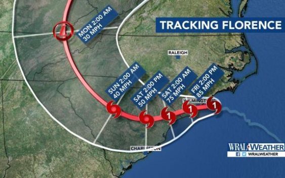
Hurricane Florence made landfall near Wrightsville Beach around 7:15 a.m. Friday as a Category 1 storm.
At a glance:
- Hurricane Florence made landfall near Wrightsville Beach around 7:15 a.m. Friday as a Category 1 storm.
- More than 500,000 customers are without power in North Carolina.
- 200 people have been rescued in New Bern and 150 are still awaiting rescue. New Bern is seeing the worst storm surge from Florence as flood waters are being pushed out of the Pamlico Sound.
- More than 12,000 people fleeing the storm have taken shelter at 126 shelters open across the state.
Latest updates:
11:42 a.m.: A tornado touched down in Bertie County at 10:30 a.m. Damages were reported but no injuries.
11:30 a.m.: The National Weather Service has issued a flood warning for the Cape Fear River with “confidence increasing in potentially catastrophic flooding in the Sandhills and the southern Coastal Plain.” A voluntary evacuation is recommended to people who live in close proximity to the river.
11:21 a.m.: South Carolina is beginning to feel the impact of Florence. Elizabeth Gardner said Florence could be in Myrtle Beach by 8 p.m.
11 a.m.: “To those in the storm’s path, if you can hear me, please stay sheltered. Do not go out in this storm,” said Gov. Roy Cooper during a briefing on Hurricane Florence.
The governor also stated that the Lumber and Cape Fear rivers are expected to crest even higher than they did following Hurricane Matthew in 2016.
“Remember, rivers will keep rising for days even if the rain stops,” he said. “Pay attention to evacuations and leave if you are told to.”
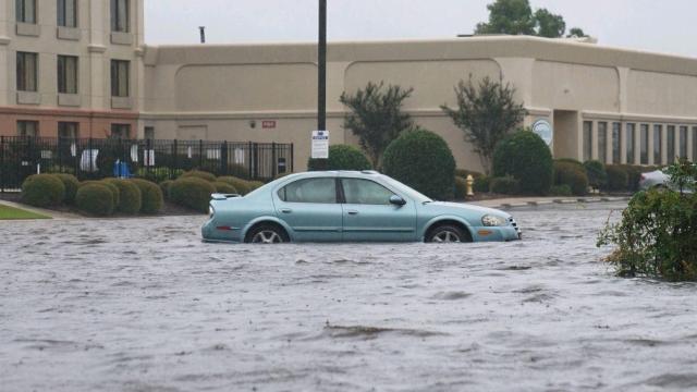
10:45 a.m.: Streets in New Bern are impassable due to downed trees. On one street, the Neuse River could be seen overflowing onto the street.
10:27 a.m.: A crew from the National Guard is rescuing a family from a flooded home in New Bern.
10:23 a.m.: Atlantic Beach and Morehead City are seeing significant flooding and damage to buildings.
10:08 a.m.: Winds recorded at 105 mph at the Wilmington airport are the strongest winds ever on record. Wilmington and Brunswick County communities like Bolivia and Oak Island have seen rainfall up to 8 inches.
9:56 a.m.: The Outer Banks is relatively calm Friday morning as Florence targets other areas. A resident in Carteret County posted photos of significant flooding on Facebook.
9:16 a.m.: The popular Bogue Inlet Pier in Emerald Isle has suffered some damage.
8:04 a.m.: The statewide power outage has jumped to 403,000.
7:58 a.m.: WECT tweeted a photo of a gas station that was severely damaged in Wilmington.
7:39 a.m.: Closer to home, the Tar River in Greenville is close to flooding. Officials say the flood stage for the river is 13 feet, and it is currently past 9 feet and rising steadily. Tranters Creek near Washington, North Carolina is experiencing minor flooding, and the town is suffering as a result.
7:26 a.m.: Wilmington is experiencing its highest wind speeds since 1960. That’s greater than Floyd and Fran.
7:15 a.m.: The storm officially made landfall in Wilmington at 7:15 a.m.
6:54 a.m.: Storm surge (the rising of the sea) in Wilmington is up to 3 feet, but major flooding has not yet been reported there. New Bern is experiencing some of the worst flooding due to overflow from the Pamlico River. The eyewall of the storm is spinning on the coast near Topsail Island, but the National Hurricane Center has not confirmed that center of the eye has made landfall.
6:32 a.m.: The statewide power outage is now at more than 340,000. Crews from Greenville are traveling to New Bern to assist crews with more than 100 rescues.
6:10 a.m.: Wilmington will deal with the storm’s eyewall for several hours as the storm slowly moves onshore. Amanda Lamb is in Wilmington and reported that large pieces of sheet metal were flying through the air and car alarms were sounding. Wilmington is currently experiencing winds at 85 mph. The top winds from the storm were recorded at 106 mph in Cape Lookout.
5:55 a.m.: Hurricane Florence is expected to make landfall near Topsail Beach.
5:53 a.m.: A household in New Bern has tweeted that they need help. They are stuck in their attic and their home is flooded. They are among dozens waiting on crews.
5:44 a.m.: Officials in New Bern said crews have been working to rescue at least 200 people overnight. There are about 150 people waiting to be rescued.
5:23 a.m.: About 70 occupants have been evacuated from a hotel in Jacksonville, North Carolina after hurricane force winds threatened the structural integrity of the building. The group, which included an infant, children and pets, have been taken to the Jacksonville Center for Public Safety after portions of the roof collapsed. No one was injured.
5:16 a.m.: The Outer Banks is now in better shape, but Wilmington is being pounded with rain and winds as the center of the storm gets closer to making landfall.
5:09 a.m.: WRAL reporter Amanda Lamb was barely able to keep her balance in Wilmington while standing outside in 70 mph winds.
5 a.m.: The latest update from the National Hurricane Center shows little change to Florence’s path or strength. The Category 1 storm has maximum sustained winds of 90 mph and is moving slowly, at 6 mph.
4:37 a.m.: A whopping 280,000 customers are without power in North Carolina. The highest numbers are being reported in New Hanover County.
4:13 a.m.: We will get an updated look at Florence’s projected path at 5 a.m.
4 a.m.: Twenty-eight roads are closed in New Hanover County due to flooding, and power outages are widespread. In Craven County, New Bern’s mayor says the town has seen historic flooding, with as much as 10 feet of water reported in some places. Highway 12 is still closed in Dare County. The road closed Thursday afternoon when it flooded 15 hours before Florence was expected to make landfall.

