- Couple accused of creating videos of young girls using hidden cameras at The Woodlands Mall, Hurricane Harbor
- Couple accused of creating videos with hidden cameras at The Woodlands Mall, Hurricane Harbor
- The Texanist: Texas Gets More Tornadoes Than Any Other State, but Don’t Freak Out
- U.S. Supreme Court says Texans can sue state for flood damage
- This is how many hurricanes NC State researchers predict this year
Florence flooding live coverage: Storm 'has never been more dangerous than it is right now'
Florence, now a tropical depression, is still a dangerous storm and is expected to dump excessive rainfall on wide areas of North Carolina and South Carolina, causing historic flooding.
Officials also say the storm could kick up a few tornadoes on its trek across the region.
The storm has reached the height of danger, Governor Roy Cooper said in a press conference on Sunday afternoon.
“The storm has never been more dangerous than it is right now,” he said.
The Marines, the Coast Guard, civilian crews and volunteers used helicopters, boats and heavy-duty vehicles Saturday to rescue scores of people trapped by Florence’s shoreline onslaught, even as North Carolina braced for what could be the next stage of the disaster: widespread, catastrophic flooding inland.
ABC11 is providing live, nonstop coverage of Hurricane Florence. For regular programming go to 11.2.
Click here for how to find 11.2
There have been at least 10 people confirmed killed in North Carolina as a result of the storm. Three people died in South Carolina.
A day after blowing ashore with 90 mph winds, Florence practically parked itself over land all day long and poured on the rain. With rivers rising toward record levels, thousands of people were ordered evacuated for fear the next few days could bring the most destructive round of flooding in North Carolina history.
Florence was downgraded to a tropical depression on Sunday.
Watch: Family of evacuees seeks shelter in Harnett County
Hurricane Florence: How you can help the victims
Downloading the ABC11 app is the best way to stay up-to-date on the latest conditions from Hurricane Florence.
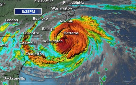
LATEST RADAR IMAGE:
Among the dead are a mother and baby who died after a tree fell on their home. Another person died as a result of a medical incident in Pender County, according to Pender County Emergency Management Director Tom Collins. The woman was at her home in Hampstead. Emergency crews were unable to get to her because of a downed tree in the road. Her death was later attributed to Florence.
Hurricane Florence made landfall just before 7:30 Friday morning in Wrightsville Beach as Category 1 storm with maximum 90 mph winds.
New Bern quickly started to flood, causing more than 100 water rescues.
RELATED: How the Food Bank of Central and Eastern North Carolina is helping Florence evacuees
ABC11’s Julie Wilson accompanied one team of volunteers and helped save a dog.
The state has opened more than 120 shelters for Florence evacuees.
Scroll down for latest updates
POWER OUTAGES: Thousands without power. Stay updated on outages here.
2 a.m.
Rivers are swelling toward record levels, forecasters now warn, and thousands of people have been ordered to evacuate for fear that the next few days could bring the most destructive round of flooding in North Carolina history
Florence picked up speed as it headed westward, moving along at 6 mph, double the clip from Saturday, some faint hope for those in the most flood-prone areas.
At 2 a.m. Sunday, Florence was about 25 miles southeast of Columbia, South Carolina.
11 p.m.
Florence remained a tropical storm, with maximum sustained winds of 40 mph.
8:10 p.m.
Duke Energy says heavy rains from Florence have caused a slope to collapse at a coal ash landfill at a closed power station outside Wilmington.
Duke spokeswoman Paige Sheehan said Saturday evening that about 2,000 cubic yards of ash have been displaced at the Sutton Plant and that contaminated stormwater likely flowed into Sutton Lake, the plant’s cooling pond. The company hasn’t yet determined if the weir that drains the cooling pond was open or whether any contamination may have flowed into the swollen Cape Fear River.
Sheehan says the company had reported the incident to state and federal regulators.
Sutton was retired in 2013 and the company has been excavating ash to remove to safer lined landfills. The gray ash left behind when coal is burned contains toxic heavy metals, including lead and arsenic.
8 p.m.
The core of Tropical Storm Florence is drifting westward over South Carolina, threatening more flash floods and major river flooding.
The National Hurricane Center said Florence was located around 8 p.m. Saturday about 65 miles east-southeast of Columbia, the South Carolina capital. Its top sustained winds have dropped some to 45 mph and Florence is crawling along at 2 mph (4 kph).
Forecasters say that Florence is still a dangerous storm and is expected to dump excessive rainfall on wide areas of North Carolina and South Carolina. They also say the storm could kick up a few tornadoes on its trek across the region.
5 p.m.
Florence remained a tropical storm with maximum-sustained winds of 45 mph. It was creeping west at 2 mph and could possibly be downgraded to a tropical depression by Sunday.
3:30 p.m.
Authorities said at a press conference that the impact of Florence would be felt for days to come.
“Let me assure you – this flooding is only going to get worse,” North Carolina’s director of emergency management Mike Sprayberry said.
Authorities said 100 primary roads have been affected by the storm so far.
RELATED: NC Road closures and re-openings
2 p.m.
In Morehead City, Florence broke a state record for highest rainfall total by a tropical system.
1 p.m.
Water boil advisory issued for Wayne County as officials evaluate water outages in Southeastern Wayne Sanitary District area.
12 p.m.
Tornado Warning issued for Duplin County until 12:15 p.m.
Tornado Warning issued for Sampson County until 11:45 a.m.
11 a.m.
During a news conference, Gov. Cooper instructs residents who have evacuated to “stay put.”
“We know that people are anxious to get back home, but don’t go back until this storm passes, and you get the official all-clear.”
He said rivers, creeks, and other waterways are expected to rise and possibly crest on Monday.
10 a.m.
The White House says President Donald Trump has issued a disaster declaration for North Carolina and that will make federal money available to people in the counties of Beaufort, Brunswick, Carteret, Craven, New Hanover, Onslow, Pamlico and Pender.
Government aid can include grants for temporary housing and home repairs, low-cost loans to cover uninsured property losses, and other programs to help individuals and business owners recover from the effects of Hurricane Florence.
Money also is available to the state, some local governments, and some private nonprofit groups on a cost-sharing basis for emergency work in those counties.
8:30 a.m.
Mandatory evacuation issued for Harnett County residents along the Lower Little River near the Cumberland County line.
The National Weather Service is now predicting the Lower Little River at Manchester to crest at 35.4 feet at approximately 8 a.m. Monday.
A third emergency shelter will open at Western Harnett High School at noon.
7 a.m.
Tornado Watch issued for Wilson, Moore and Lee counties until 5 p.m.
Full list of counties under Tornado Watch here.
5 a.m.
The storm was located 35 miles west of Myrtle Beach, South Carolina.
The storm was moving at 5 mph with 50 mph winds.
Storm Surge Warnings are in effect for Myrtle Beach, South Carolina to Ocracoke Inlet, North Carolina, and Pamlico Sound, including the Neuse and Pamlico Rivers.
1:30 a.m.
Tropical Storm Florence is practically stalled over the Carolinas and the monster storm could dump drenching rains of up to 3 feet. That, in turn, could trigger epic flooding well inland.
Gov. Roy Cooper calls Florence the “uninvited brute” that could wipe out entire communities. The storm is still roughly 400 miles wide.
Early Saturday morning Florence’s winds weakened to 65 mph as it moved forward at 5 mph and was about 15 miles west-northwest of Myrtle Beach, South Carolina.
(Copyright ©2018 ABC11-WTVD-TV/DT. All Rights Reserved – The Associated Press contributed to this report.)