- Habitat for Humanity helping Rock Hill residents assess, clean up storm damage. They are also seeking volunteers
- Smokehouse Creek wildfire victims line up lawsuits against utility
- Will Mexico wildfires impact Houston's air quality?
- The worst tornadoes in North Carolina History
- Hurricane-proof your NC home: Essential steps to weather the storm
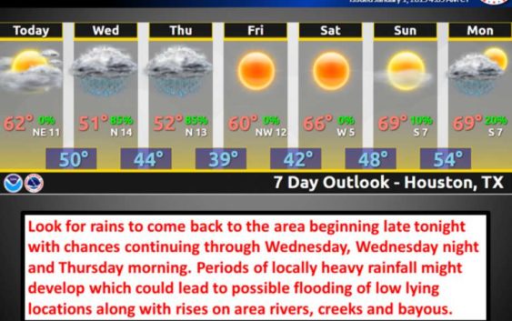
Flooding possible for Houston area with rain in the forecast through Thursday
-
PHOTOS: Where are the most flood-prone spots in Houston ?
The Houston-area could see as much as three inches of rain in most areas with continuous rain in the forecast through Thursday.
>>> See some of the roads that typically get barricaded during a flood
PHOTOS: Where are the most flood-prone spots in Houston ?
The Houston-area could see as much as three inches of rain in most areas with continuous rain in the forecast through Thursday.
>>> See some of
Photo: National Weather Service
PHOTOS: Where are the most flood-prone spots in Houston ?
The Houston-area could see as much as three inches of rain in most areas with continuous rain in the forecast through Thursday.
>>> See some of the roads that typically get barricaded during a flood
PHOTOS: Where are the most flood-prone spots in Houston ?
The Houston-area could see as much as three inches of rain in most areas with continuous rain in the forecast through Thursday.
>>> See some of
Photo: National Weather Service
Houston residents are in for a wet and potentially dangerous couple of days as continuous heavy rainfall threatens to flood the area in the first days of 2019.
A flash flood watch is in effect from Wednesday morning to Thursday, when heavy rainfall is expected to bring up to 3 inches of rain to the city, according to the National Weather Service. Expect higher amounts in some low-lying areas.
RELATED: This FEMA interactive allows you to enter any address and see the flood risk in Houston
Houston-area residents should be cautious of creeks, rivers and bayous over the next few days, and they should also stay on top of high-water risks on highways using the Houston TranStar Map.
The forecast shows the rain dying down by Thursday night, with temperatures cooling to a 39-degree low. A crisp, clear weekend lies ahead with a sunny Friday, Saturday and Sunday.
Earlier in the week, thick layers of fog and New Year’s Day firework smoke created poor air and driving conditions throughout the city.
Julian Gill is a digital reporter in Houston. Read him on our breaking news site, Chron.com, and on our subscriber site, houstonchronicle.com. | julian.gill@chron.com | Text CHRON to 77453 to receive breaking news alerts by text message