- Before and after: See Dubai flooding from space
- No evidence of a tornado in Rock Hill, investigation determines
- Marking 15 years since 19,000 acre wildfire destroyed dozens of homes in Horry County
- 'I am so sorry, but we will do it again' Donald Trump calls off Wilmington rally due to severe weather
- Donald Trump forced to call off Wilmington rally due to severe weather
FIRST ALERT: Tornado Watch in western counties; SA could see severe weather by daybreak
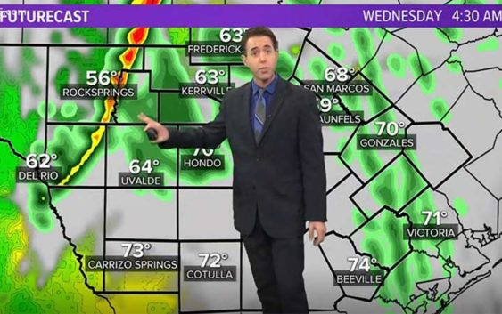
San Antonio and south Texas are lined up for possible severe storm activity early Wednesday morning.
KENS 5 meteorologist Jeremy Baker says you can expect a squall line of storms to roll through western counties from 3 to 6 a.m., central counties (including Bexar County) around 6 to 9 a.m., then tapering off in the eastern counties before noon.
CURRENT NATIONAL WEATHER SERVICE ALERTS:
- A Tornado Watch is in effect for Edwards, Kinney, Real and Val Verde counties until 5 a.m. The storm there has a history of producing 3/4-inch hail and winds in excess of 60 mph.
- A wind advisory is in effect overnight through 8 a.m. for most counties west and north of San Antonio, including Bandera, Bexar, Blanco, Comal, Edwards, Gillespie, Kendall, Kerr, Medina, Real, Uvalde and Val Verde counties in the KENS 5 viewing area. Sustained winds of 20 to 25 mph were expected, with gusts of 30 to 40 mph possible.
The squall line was expected to weaken as it progresses across Texas, so the best chance of severe weather is west of Bexar County.
Jeremy says the main threats are thunderstorms and damaging winds, but large hail and brief isolated weak tornadoes can’t be ruled out.
AFTER THE STORM:
Behind the cold front, skies will clear up in the afternoon and it will be warm with highs in the upper 70s and lower 80s. Highs will drop into the lower 70s Thursday, then the lower 60s Friday.
We will stay dry through Saturday, with the next chance for rain on Sunday with highs staying in the lower 60s. Temperatures warm back into the 70s for the first part of the next work week.