- The Texanist: Texas Gets More Tornadoes Than Any Other State, but Don’t Freak Out
- U.S. Supreme Court says Texans can sue state for flood damage
- This is how many hurricanes NC State researchers predict this year
- NC State researchers predict above-average hurricane season
- Supreme Court rules in favor of property owners suing Texas over flood damage
The Latest: Tornado warnings issued for Vance, Warren, Granville and Franklin counties
Raleigh, N.C. — LATEST DEVELOPMENTS:
- Entire Triangle area under Level 4 risk for severe weather that extends until 11 p.m. Friday.
- Several counties are under a tornado watch, including Alamance, Chatham, Durham, Harnett, Orange, Person, and Wake. Meteorologist Elizabeth Gardner said almost 2.5 million people live in the affected areas.
- Chapel Hill-Carrboro City Schools dismissing early today; several churches have canceled Good Friday activities.
- Gardner says the greatest risk for severe weather, including tornadoes, starts at 3 p.m. and extends to 10 p.m.
11:06 a.m. — A tornado warning was issued for Vance County, west central Warren County, northeastern Granville County and northwestern Franklin County.
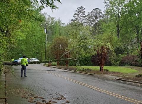
10:50 a.m. — A tree was reported down on power lines in Raleigh off of Glenwood Avenue.
10:45 a.m. — A tornado watch was issued for several counties in central North Carolina.
10:30 a.m. — The active tornado warnings have expired.
10:07 a.m. — The tornado warning for Orange County has been canceled.
10 a.m. — A tornado warning has been issued for Caswell County until 10:30 a.m.
9:46 a.m. — A tornado warning has been issued for Orange, Alamance and Person counties until 10:30 a.m.
The U.S. Storm Prediction Center upgraded the Triangle’s threat for severe weather on Friday to a level 4 of 5, which means the area is at a major risk for severe thunderstorms, particularly in the evening.
“We hardly ever see a risk that’s this high in our area,” meteorologist Elizabeth Gardner said, adding that it’s important to have a severe weather preparedness plan for yourself and your family.
The last time Central and Eastern North Carolina was under a level 4 risk was in February 2016.
On Friday morning, organizations were already preparing for the storm. Chapel Hill-Carrboro City Schools will dismiss students two hours early. The Durham Rescue Mission canceled its Easter celebration because of the storm’s danger.
The storm system is expected to come in two waves, Gardner said: one around midday and one in the evening.
While scattered showers are possible in the Triangle around 7 and 8 a.m., one of the storm waves will come in around 11 a.m. Isolated thunderstorms are possible.
There’s a lull in activity around 3 p.m., but an even more intense storm arrives around 5 p.m.
It is expected to bring dangerous winds, large hail, downpours and tornadoes.
WRAL’s power outage index model was predicting outages throughout the state, with outages becoming dense between 9 and 11 p.m.
The incoming storm system has already produced a cluster of tornadoes in the Jackson, Mississippi, area. Numerous instances of wind damage were reported in Mississippi, Louisiana and Alabama on Thursday.
Two people in Mississippi and one person in Alabama died in the storms.

The storm is expected to move east out of the Triangle around 11 p.m.
An inch to an inch and a half of rain is expected in the Triangle.
WRAL traffic reporter Brian Shrader advises drivers to stay off the road if possible during the storm. It’s dangerous to drive through flooded streets, and motorists should turn around if they encounter any.
