- The Texanist: Texas Gets More Tornadoes Than Any Other State, but Don’t Freak Out
- U.S. Supreme Court says Texans can sue state for flood damage
- This is how many hurricanes NC State researchers predict this year
- NC State researchers predict above-average hurricane season
- Supreme Court rules in favor of property owners suing Texas over flood damage
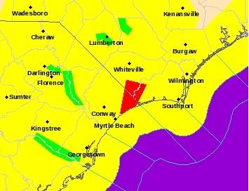
Tornado watch for SE NC until midnight
The Wilmington region is under a tornado watch until midnight; threat of heavy rains also in forecast
SOUTHEASTERN N.C. — Severe weather was beginning to impact the area early Friday afternoon, with all of Southeastern North Carolina under a tornado watch.
The tornado watch, which went into effect at 1:15, will remain until midnight, according to the National Weather Service’s Wilmington office (NWS). A tornado watch means weather conditions are favorable for a tornado and residents should be ready to act quickly if a warning is issued.
According to a NWS forecast, a strong cold front is likely to bring “strong to severe” thunderstorms to the region throughout the afternoon and evening. The front causing the storms is likely to move off the coast around 10 p.m., per the NWS.
“Damaging wind will be the biggest threat,” the forecast stated, “but tornadoes will also be possible.”
Burgaw, Leland and Wilmington will begin seeing more impacts around 6 p.m., with the risk rising throughout the evening, according to an NWS briefing. The highest risk — “moderate risk” — will come between 8 and 10 p.m.
“A moderate risk from the Storm Prediction Center is relatively rare in the Carolinas. It is used to convey higher-end severe weather events that border on being outbreaks,” the NWS briefing stated.
Additionally, the NWS has enacted a wind advisory for all of the coastal counties until 11 p.m., meaning sustained winds between 31 and 39 mph are expected, with gusts between 46 and 57 mph.
“Gusty winds will blow around unsecured objects,” the NWS briefing stated. “Tree limbs could be blown down and lead to a few power outages and minor damage.”
Several flights out of Wilmington International Airport have been delayed, while three flights between ILM and Charlotte have been canceled.
The storms are expected to drop about 1.65 inches of rain on Wilmington, with the rest of Southeastern N.C. seeing between 1 and 2 inches.
Minor coastal flooding is possible along beaches, the NWS warned, with south-facing beaches particularly susceptible Friday night. Downtown Wilmington is also “likely” to see minor coastal flooding during the high tide just before 11 p.m.
Contact the Metro desk at 910-343-2384 or Breakingnews@StarNewsOnline.com.