- Couple accused of creating videos of young girls using hidden cameras at The Woodlands Mall, Hurricane Harbor
- Couple accused of creating videos with hidden cameras at The Woodlands Mall, Hurricane Harbor
- The Texanist: Texas Gets More Tornadoes Than Any Other State, but Don’t Freak Out
- U.S. Supreme Court says Texans can sue state for flood damage
- This is how many hurricanes NC State researchers predict this year
Storm timeline: Flooding concerns linger behind storms
AUSTIN, Texas — Scattered to numerous showers and thunderstorms will be likely Wednesday. Several storms could be strong or severe.
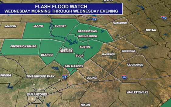
Along with the severe threat, heavy rainfall could provoke additional flash flooding. A Flash Flood Watch will be in effect Wednesday for metro counties and for most of the Hill Country.

kvue
A flood warning has been issued for the Pedernales River at Johnson City until Thursday evening. The river is expected to crest at 17.3′.
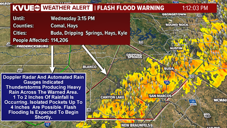
There is also a flash flood warning in place for Hays County until 3:15 p.m. after heavy rain impacted the region.
Flash Flood Warning
KVUE
WATCH: The Importance of “Turn Around, Don’t Drown”
Some low water crossings are closed due to heavy rainfall and more will likely close as heavy rain moves into the Austin area. Be sure to stay out of flooded areas. You can find out what low water crossings are closed by clicking here.
A flash flood warning is in place for Hays County until 3:15 p.m. on Wednesday.
Here are weather updates from Nathan Gogo.
As storms moved over Kerrville before 7:30 a.m. Wednesday, golf ball-sized hail was reported there.
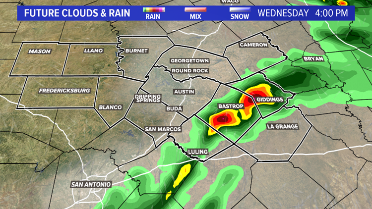
Through the early and mid-afternoon, thunderstorms will move into counties east of the interstate.

kvue
Storms will linger across parts of the area through the late afternoon and early evening.
kvue
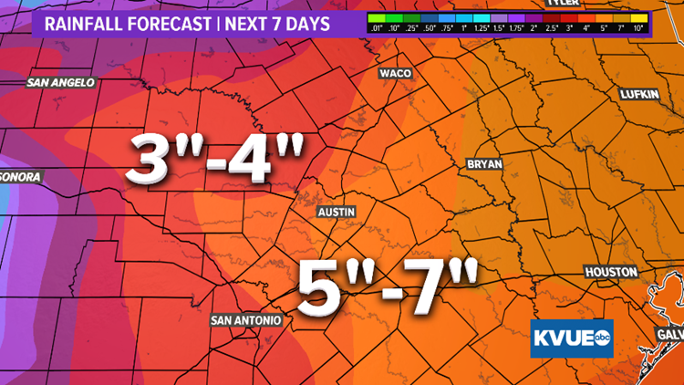
Although the severe weather threat decreases, heavy rain chances continue Thursday, Friday and Saturday. Rainfall amounts over the next several days could range from three to four inches for areas from Austin westward, and five to seven inches for areas from Austin eastward.
kvue
May is typically our wettest and most active time of the year when it comes to severe weather and this forecast is a testament to that. Stay up to date with KVUE as we continue through the severe weather season here in Texas. Download KVUE’s app for updates and follow KVUE on YouTube, Facebook, Twitter and Instagram.
RELATED:
Colorado River levels dropping downstream from Austin
LCRA to open floodgate at Tom Miller Dam
Two floodgates opened at Longhorn Dam in East Austin after recent flooding
VIDEO: Flooding at Barton Springs Pool
PEOPLE ARE ALSO READING:
‘Game of Thrones’ left a coffee cup in this week’s episode and the internet is losing it
San Marcos police investigating apparent murder-suicide of Texas State students
The 17 best deals and freebies for Teacher Appreciation Day and week