- Couple accused of creating videos of young girls using hidden cameras at The Woodlands Mall, Hurricane Harbor
- Couple accused of creating videos with hidden cameras at The Woodlands Mall, Hurricane Harbor
- The Texanist: Texas Gets More Tornadoes Than Any Other State, but Don’t Freak Out
- U.S. Supreme Court says Texans can sue state for flood damage
- This is how many hurricanes NC State researchers predict this year
Entire Area Under Flood Watch Through Saturday
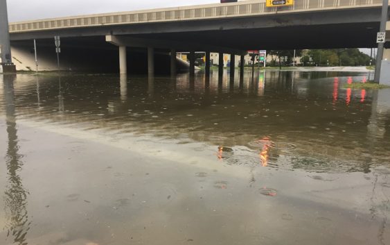
After a wild round of thunderstorms Tuesday, Wednesday and much of the day Thursday were quiet with only small pockets of light rain falling around the region. It is expected that heavy rain and thunderstorms will begin filtering into the Houston area late this afternoon and early into the evening with plenty of rain overnight and into the early morning hours.
The entire region is forecast to receive between 5 and 8 inches of rain between Thursday night and Sunday morning with some areas certain to receive perhaps double that amount, which is why the National Weather Service issued a Flash Flood Watch Thursday afternoon that runs until 7 p.m. Saturday night.
In anticipation of this, Houston Community College commencement and graduation ceremonies originally scheduled for this Saturday have been rescheduled for Friday, May 17 at NRG Stadium. Updates will be posted throughout the week.
The AsiaFest scheduled for this Saturday has been re-scheduled for June 29-30 because of the flood risk this weekend it was announced today.
In an afternoon joint press conference between the city of Houston and Harris County, County Judge Lina Hidalgo urged people to go straight home this evening. TranStar tweeted out a prediction that there could be local heavy rainfall and flooding and urged travelers to check its traffic map. The Houston ISD, however, appeared to be going ahead with its monthly public board meeting scheduled to start at 5 p.m. today.
Our atmosphere is super charged with moisture and there are a pair of frontal boundaries to our north that are sagging their way into the area drawing water off the Gulf of Mexico. Additionally, there is a small disturbance to the southwest moving up the coast line that should converge in the area later tonight. That combination should produce fairly explosive results tonight and into tomorrow morning.
Both the Trinity and Brazos Rivers are already swollen though area bayous have mostly receded since Tuesday. The biggest threat is river flooding and flash flooding int areas hardest hit by the rain. Just because you didn’t get flooded during Harvey doesn’t mean a flash flood couldn’t create issues for you over the next couple days, so be prepared.
The big question is where will the worst occur and, unfortunately, with a region as large as ours, that is nearly impossible to predict. The latest weather models would seem to indicate the worst of it will stay close to and south of Interstate 10 on the westernmost portions of the area and south of perhaps the Livingston area to the east. That would seem to put the southwest and northeast portions of the area in the crosshairs, which isn’t good news considering all the rain they got Tuesday.
But, that is just a guess at this point. Any slow moving storm system could drop 2 to 3 inches of rain per hour on virtually any spot from Galveston to Huntsville, Columbus to the Texas-Louisiana border. We will update this story as we get new information.