- Couple accused of creating videos of young girls using hidden cameras at The Woodlands Mall, Hurricane Harbor
- Couple accused of creating videos with hidden cameras at The Woodlands Mall, Hurricane Harbor
- The Texanist: Texas Gets More Tornadoes Than Any Other State, but Don’t Freak Out
- U.S. Supreme Court says Texans can sue state for flood damage
- This is how many hurricanes NC State researchers predict this year
Flash Flood Watch in effect: Heavy rain expected
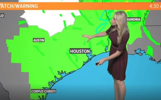
HOUSTON — The Houston area has a moderate risk of seeing more flooding rains Thursday, Friday and Saturday, says KHOU 11 Meteorologist Chita Craft. Areas west of Houston stretching into DFW and Louisiana have a slight risk of flooding.
The National Weather Service has issued a Flash Flood Watch from 1 p.m. Thursday lasting until 7 p.m. Saturday. View the impacted communities and weather timeline at the bottom of this article.
SCHOOL CLOSURES: List of school closures for Thursday
WEATHER ALERTS: View weather alerts/watches/warnings
RADAR: Track rain & storms across Texas
GET ALERTS ON YOUR PHONE: Download the KHOU 11 app and follow us on Facebook and Twitter.
Flash Flood Watch: Which communities are impacted?
The Thursday to Saturday watch covers nearly all of Southeast Texas, including the counties/communities of Austin, Brazoria Islands, Brazos, Burleson, Chambers, Coastal Brazoria, Coastal Galveston, Coastal Harris, Coastal Jackson, Coastal Matagorda, Colorado, Fort Bend, Galveston Island and Bolivar Peninsula, Grimes, Houston, Inland Brazoria, Inland Galveston, Inland Harris, Inland Jackson, Inland Matagorda, Madison, Matagorda Islands, Montgomery, Northern Liberty, Polk, San Jacinto, Southern Liberty, Trinity, Walker, Waller, Washington and Wharton.

Flash Flood Watch beginning at 1 p.m. Thursday
KHOU 11
Weather Timeline: When the heaviest rain is expected
THURSDAY – 70% chance of storms and rain in Houston area, mostly scattered in the morning and becoming heavier and more widespread in the late afternoon and evening. High water spots possible due to saturated ground conditions.
FRIDAY – 60% chance of thunderstorms continues in the early-morning hours, becoming more scattered in the afternoon. Friday evening and the overnight hours heading into Saturday the showers will again become more widespread – continuing our potential to see more flooding. We’ll have to watch and wait to see which area watersheds get the most rain and which creeks and bayous threaten to flood again.
SATURDAY- 90% chance for rain all day with thunderstorms. Flood risk continues from the morning through the afternoon. Thunderstorms are possible in the evening, becoming partly cloudy in the late evening heading into Sunday. The flood watch does not expire until 7 p.m.
SUNDAY- 20% rain chance, high of 82 – calmer conditions for Mother’s Day with the flood risk finally dissipating.
MONDAY- Slight chance for scattered showers continues, temps in the low-80s.
TUESDAY & WEDNESDAY – Stormy forecast returns with about a 50% rain chance.