- Couple accused of creating videos of young girls using hidden cameras at The Woodlands Mall, Hurricane Harbor
- Couple accused of creating videos with hidden cameras at The Woodlands Mall, Hurricane Harbor
- The Texanist: Texas Gets More Tornadoes Than Any Other State, but Don’t Freak Out
- U.S. Supreme Court says Texans can sue state for flood damage
- This is how many hurricanes NC State researchers predict this year
WATCH LIVE: Flash Flood Watch goes into effect Thursday afternoon
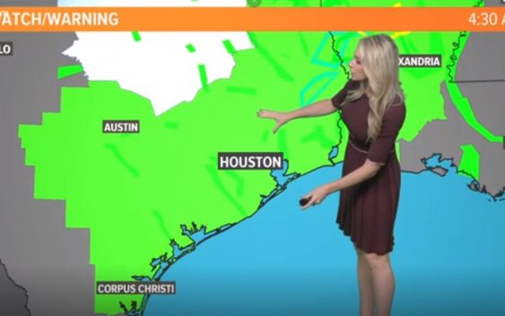
HOUSTON — More wet weather is on the way in the form of potentially flooding rains.
The National Weather Service has issued a Flash Flood Watch that will go into effect at 1 p.m. Thursday lasting until 7 p.m. Saturday.
Meteorologist Chita Craft is tracking the nasty weather on #HTownRush – streaming live in the player above and on KHOU 11.
SCHOOL CLOSURES: List of school closures for Thursday
CURRENT ALERTS: View weather alerts/watches/warnings
RADAR: Track rain & storms across Texas
GET ALERTS ON THE GO: Download the KHOU 11 app and follow us on Facebook and Twitter.
The watch covers nearly all of Southeast Texas, including the communities of
Austin-Brazoria Islands-Brazos-Burleson-Chambers-Coastal Brazoria-
Coastal Galveston-Coastal Harris-Coastal Jackson-
Coastal Matagorda-Colorado-Fort Bend-
Galveston Island and Bolivar Peninsula-Grimes-Houston-
Inland Brazoria-Inland Galveston-Inland Harris-Inland Jackson-
Inland Matagorda-Madison-Matagorda Islands-Montgomery-
Northern Liberty-Polk-San Jacinto-Southern Liberty-Trinity-Walker-
Waller-Washington-Wharton-
Including the cities of Alvin, Anahuac, Angleton, Bay City,
Baytown, Bellville, Brenham, Brookshire, Bryan, Caldwell,
Cleveland, Clute, Coldspring, College Station, Columbus, Conroe,
Corrigan, Crockett, Dayton, Devers, Dickinson, Eagle Lake, Edna,
El Campo, First Colony, Freeport, Friendswood, Galveston, Ganado,
Groveton, Hempstead, Houston, Huntsville, La Marque,
Lake Jackson, League City, Liberty, Livingston, Madisonville,
Mission Bend, Missouri City, Mont Belvieu, Navasota,
Old River-Winfree, Palacios, Pasadena, Pearland, Pecan Grove,
Prairie View, Rosenberg, Sealy, Shepherd, Somerville, Stowell,
Sugar Land, Surfside Beach, Texas City, The Woodlands, Trinity,
Waller, Weimar, Wharton, and Winnie
The KHOU 11 Weather Team is closely monitoring the potential for more heavy rain and moderate flooding – especially as we head into Thursday, Friday and Saturday.
WEATHER TIMELINE:
THURSDAY – 70% chance of storms and rain in Houston area, mostly scattered in the morning and becoming heavier and more widespread in the evening. High water spots possible due to saturated ground conditions.
FRIDAY – 60% chance of thunderstorms continues in the early-morning hours, becoming more scattered in the afternoon. Friday evening and the overnight hours heading into Saturday the showers will become more widespread – continuing our potential to see more flooding. We’ll have to watch and wait to see which area watersheds get the most rain and which creeks and bayous threaten to flood again.
SATURDAY- 90% chance for rain all day with thunderstorms. Flood risk continues from the morning through the afternoon. Thunderstorms are possible in the evening, becoming partly cloudy in the late evening heading into Sunday.
SUNDAY- 20% rain chance, high of 82 – calmer conditions for Mother’s Day with the flood risk finally dissipating.
NEXT WEEK- Scattered showers early in the week with another chance for storms Tuesday.
RELATED: 400 homes reportedly flooded in Kingwood
RELATED: Cleveland ISD and New Caney ISD both closed Wednesday due to flooding