- Habitat for Humanity helping Rock Hill residents assess, clean up storm damage. They are also seeking volunteers
- Smokehouse Creek wildfire victims line up lawsuits against utility
- Will Mexico wildfires impact Houston's air quality?
- The worst tornadoes in North Carolina History
- Hurricane-proof your NC home: Essential steps to weather the storm
Flash flood warning in effect for several counties
HOUSTON — A flash flood warning is in effect until 9:30 p.m.Thursday for Harris, Fort Bend and Waller counties.
A severe thunderstorm warning is in effect until 8:30 p.m. Thursday for Harris, Montgomery and Waller counties.
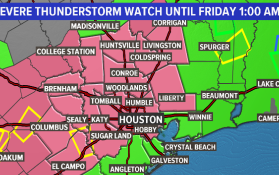
A severe thunderstorm watch is in effect until 1 a.m. Friday for Harris, Fort Bend, Wharton and Colorado counties.
The Weather Prediction Center has placed all of southeast Texas in a moderate risk of excessive rainfall for Thursday night, Friday and Saturday.
RADAR: Track rain & storms across Texas
WEATHER ALERTS: View weather alerts/watches/warnings
RELATED: LIST: Current high water locations on major roads
Southwest Airlines has canceled 70 arrival and departure flights after 8 p.m. Thursday and 29 flights Friday. A ground stop is in effect until 7:30 p.m. Thursday at Bush Airport. Tap here to view the latest flight cancellations.
A Flash Flood Watch remains in effect for all counties in southeast Texas until Saturday evening.
After a quiet afternoon, the radar is now beginning to show signs of life with heavy rain developing to the southwest of Houston.
“Storms are already starting to pop up across southeast Texas,” KHOU 11 News Meteorologist Blake Mathews said at 6:30 p.m.
The ongoing forecast remains on track with extremely heavy rainfall moving in through the late evening hours of Thursday night and into Friday morning.
Due to Tuesday’s deluge, bayou, river and small stream flooding is a much more pressing threat than it otherwise would be.
SCHOOL CANCELLATIONS: List of school cancellations, graduation postponements
GET ALERTS ON YOUR PHONE: Download the KHOU 11 app and follow us on Facebook and Twitter.
Current rainfall amounts will vary from as low as 3 or 4 inches to as much as 12+ inches and even some totals higher still.
The National Weather Service wanted to get across a few main points:
1. Minor to moderate river flooding is ongoing and is expected to continue. Conditions could deteriorate significantly if rainfall rates are excessive and concentrated over areas already swollen.
2. Rainfall amounts will vary widely with some areas picking up between 4 and 8 inches with some receiving more than a foot. Rainfall rates could exceed 4 inches per hour which will could cause life-threatening flooding on area roadways.
3. This event will likely be a multi-day situation where flooding will be likely.
4. Meteorologist Jeff Lindner with the Harris County Flood Control District says, “once home, stay home.”
We’re getting swamped with questions about how much rain can be expected in certain neighborhoods. This is an impossible question to answer. While our models are good at giving an overall idea as to what may happen, they’re not detailed enough to know who will be hit the hardest. We’re just not that good.
The general idea is that very heavy and excessive rain is on the way. Unfortunately we’re going to be doing a lot of “nowcasting” as we await to see where the heaviest rain bands set up.
The entire KHOU weather team is here and we’ll be manning the radar all night long and doing updates on social media as well as tv as this event unfolds.
Flash Flood Watch: Which communities are impacted?
The Thursday to Saturday watch covers nearly all of Southeast Texas, including the counties/communities of Austin, Brazoria Islands, Brazos, Burleson, Chambers, Coastal Brazoria, Coastal Galveston, Coastal Harris, Coastal Jackson, Coastal Matagorda, Colorado, Fort Bend, Galveston Island and Bolivar Peninsula, Grimes, Houston, Inland Brazoria, Inland Galveston, Inland Harris, Inland Jackson, Inland Matagorda, Madison, Matagorda Islands, Montgomery, Northern Liberty, Polk, San Jacinto, Southern Liberty, Trinity, Walker, Waller, Washington and Wharton.
Weather Timeline: When the heaviest rain is expected
THURSDAY – There is a 90% chance of showers and storms tonight. They will begin as scattered showers through the evening commute and become heavier and more widespread as the night progresses. High water spots possible due to saturated ground conditions.
FRIDAY – 60% chance of thunderstorms continues in the early-morning hours, becoming more scattered in the afternoon. Friday evening and the overnight hours heading into Saturday the showers will again become more widespread – continuing our potential to see more flooding. We’ll have to watch and wait to see which area watersheds get the most rain and which creeks and bayous threaten to flood again.
SATURDAY- 90% chance for rain all day with thunderstorms. Flood risk continues from the morning through the afternoon. Thunderstorms are possible in the evening, becoming partly cloudy in the late evening heading into Sunday. The flood watch does not expire until 7 p.m.
RELATED: What you need to know before driving through floodwaters
SUNDAY- 20% rain chance, high of 82 – calmer conditions for Mother’s Day with the flood risk finally dissipating.
MONDAY- Slight chance for scattered showers continues, temps in the low-80s.
TUESDAY & WEDNESDAY – Stormy forecast returns with about a 50% rain chance.