- Couple accused of creating videos of young girls using hidden cameras at The Woodlands Mall, Hurricane Harbor
- Couple accused of creating videos with hidden cameras at The Woodlands Mall, Hurricane Harbor
- The Texanist: Texas Gets More Tornadoes Than Any Other State, but Don’t Freak Out
- U.S. Supreme Court says Texans can sue state for flood damage
- This is how many hurricanes NC State researchers predict this year
LIVE BLOG: Central Texas areas under severe Thunderstorm, Flash Flood Warnings
AUSTIN, Texas — LIVE BLOG:
A Flash Flood Warning is in effect for Kingsland, Llano and Buchanan Dam until 10 p.m. There’s also one in effect for Austin, Pflugerville and Wells Branch until 10:15 p.m. In San Marcos, Kyle and Buda, the warning is in effect until 10:30 p.m.
Until 10:45 p.m., a Flash Flood Warning is in effect for Fredericksburg, Harper and Stonewall.
In New Braunfels, San Marcos and Kyle, a severe Thunderstorm Warning is in effect until 8:30 p.m.
A severe Thunderstorm Warning was in effect for Dripping Springs, Blanco and Johnson City until 7:30 p.m. In Round Rock, Cedar Park and Georgetown, the warning was in effect until 7:15 p.m. in Kerrville, Fredericksburg and Comfort, it is in effect until 9 p.m.
A severe Thunderstorm Warning was in effect for Austin, Round Rock and Cedar Park until 8 p.m. It was also in effect for Fredericksburg, Harper and Oxford. The warning was in effect for Elgin, Bastrop and Camp Swift until 7:45 p.m.
Areas of Central Texas were also under a Tornado Warning.
The warnings were in effect in Taylor, Thrall and Coupland until 7 p.m. The warning was also in effect in Leander, Lago Vista, Llano and Hudson Bend until 7:15 p.m.
At 7:11 p.m., Texas Game Warden reported that a tour boat with 80 occupants was taking on water at Lake Buchanan. The engine compartment was flooded and the boat was disabled, beached on an island. Multiple Texas Game Wardens and first responders are responding. Wardens will be shuttling passengers to land and then bus them back to the Burnet County side of the lake after the severe weather passes. They were all safe and on shore by 7:54 p.m.
At 7:17 p.m., Lake Travis Firefighters advised those at Lake Travis to take shelter due to heavy rains and high winds. Winds of 70 mph were reported at Lake Buchanan.
At 7:36 p.m., Bluebonnet Electric reported about 5,800 customers were without power. By 8 p.m., that number rose to more than 6,200 from 20 separate outages. Click here for outages from Austin Energy.
Pedernales Electric Coop reported about 180 outages affecting 7,500 meters around 8:07 p.m. Pedernales Electric Coop outages can be found here.
EARLIER TODAY:
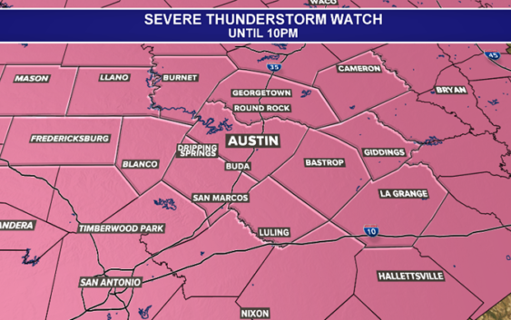
A Severe Thunderstorm Watch is in effect for the area until 10 p.m. A Severe Thunderstorm Watch means that conditions are favorable for the development of severe storms. This watch includes all of the Austin Metro.

kvue
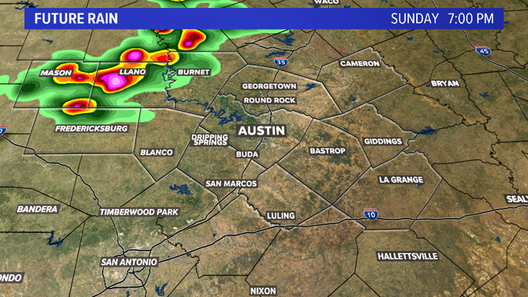
A front will approach the area Sunday evening, encountering a very hot, humid and unstable airmass. This clash of hot and humid air versus dry and cooler air will allow for the development of strong to severe thunderstorms. Thunderstorms will increase first in the northern Hill Country and northern metro after 6 p.m.
kvue
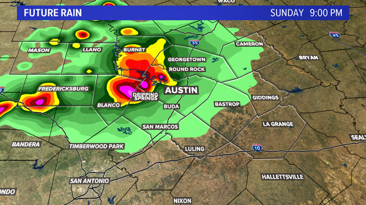
Thunderstorm chances will increase along the Interstate Highway 35 corridor during the mid-evening hours, then shift south and east in the late evening.
kvue
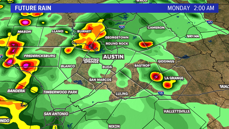
Scattered storms will be possible through the early morning hours on Monday, but the severe weather risk will decrease after 2am.
kvue
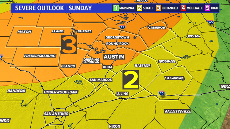
The Storm Prediction Center has placed much of the area under an “Enhanced Risk” (three out of five) for severe weather late Sunday afternoon through the pre-dawn hours on Monday. A “Slight Risk” (two out of five) is in place for areas south and east of Austin.
kvue
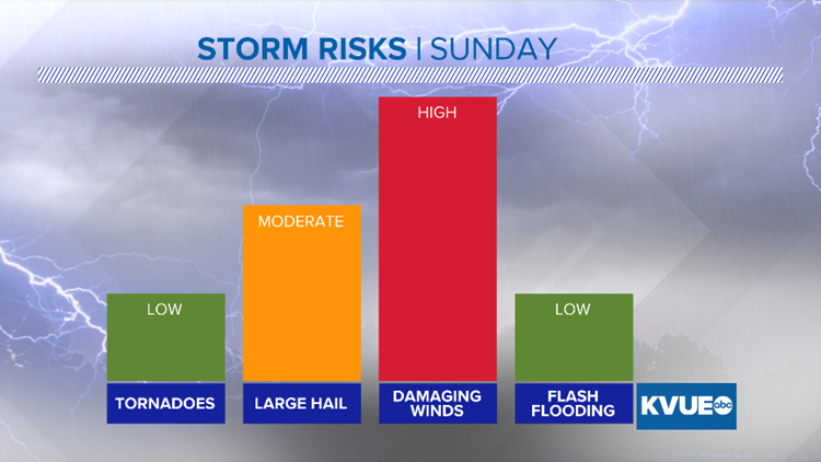
The main concern will be from severe storms producing damaging winds (60+ miles per hour). The hail threat is elevated, while the tornado risk and flood threat is low.
KVUE
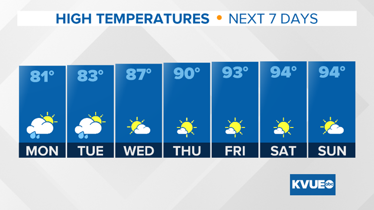
Temperatures will be cooler behind the front, with highs in the low 80s Monday and Tuesday.
KVUE
RELATED: FORECAST: Triple-digit heat Sunday; Storm chances late Sunday
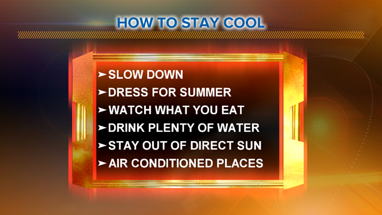
Ahead of some cooler weather next week, the heat this Sunday is dangerously hot and without proper precautions, heat exhaustion or heat stroke may ensue. Here are a few tips on how to stay cool this weekend:
kvue
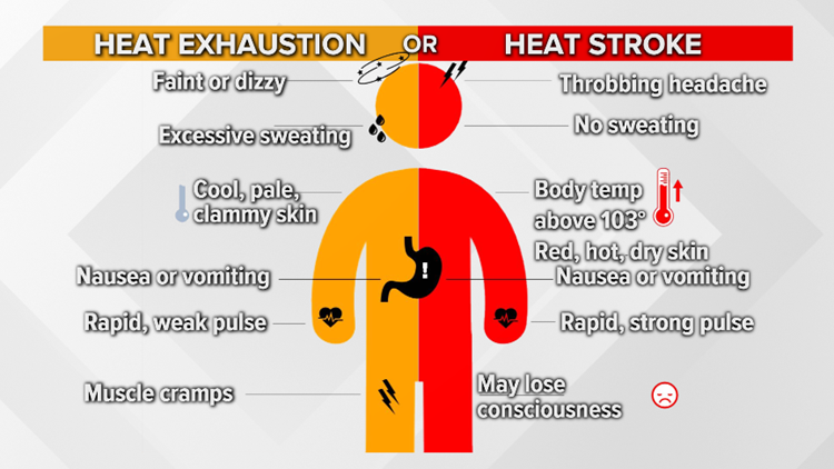
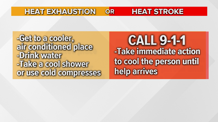
RELATED: Heat stroke vs. heat exhaustion: Know the warning signs
It will be a beautiful, sunny weekend, so should you find yourself outdoors and start to feel too hot, here are some symptoms to look out for and how to decipher between heat exhaustion and heat stroke:
kvue
kvue
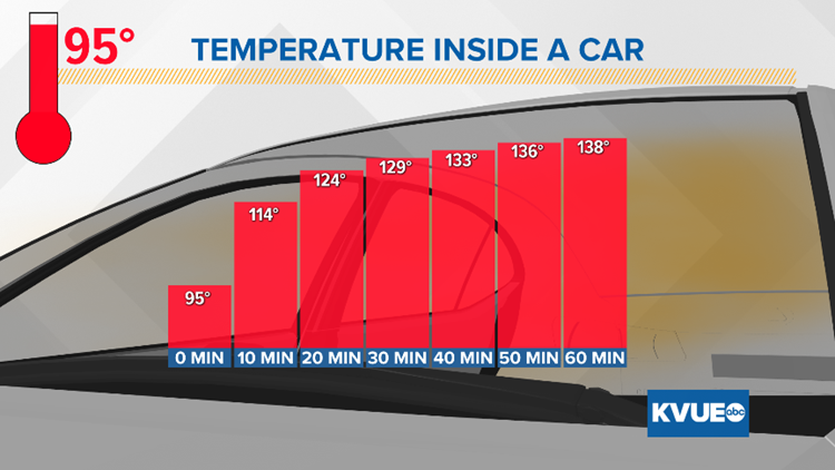
With this being our first hot stretch of 2019, don’t forget to “Beat the Heat, Check the Backseat!” According to the National Weather Service, “One of the biggest weather-related risks during the summer months is the possibility of a child dying in a vehicle from heat stroke. The temperature inside a vehicle can rise 20 degrees in as little as 10 minutes, and 50 degrees in an hour. This can cause hyperthermia (heat stroke) in literally a matter of minutes, particularly in children, whose body temperatures warm at a rate three to five times faster than an adult’s.”
kvue
We hope you all have a great weekend and are able to enjoy the beautiful summer weather – just stay cool out there!
Stay up to date with KVUE for the latest forecast by downloading KVUE’s app and following KVUE on Facebook, Twitter, YouTube and Instagram.
PEOPLE ARE ALSO READING:
‘Riv was special.’ Country star Granger Smith’s son, 3, dies after drowning
4 children killed as result of crash on U.S. 77 south of Giddings
What the Beep: Why is a lane on MoPac used only for exiting?
You can eat and sleep at the original ‘Texas Chainsaw Massacre’ gas station