- Couple accused of creating videos of young girls using hidden cameras at The Woodlands Mall, Hurricane Harbor
- Couple accused of creating videos with hidden cameras at The Woodlands Mall, Hurricane Harbor
- The Texanist: Texas Gets More Tornadoes Than Any Other State, but Don’t Freak Out
- U.S. Supreme Court says Texans can sue state for flood damage
- This is how many hurricanes NC State researchers predict this year
Severe weather topples trees, causes damage
CHARLOTTE, N.C. — A line of severe thunderstorms moving across the western North Carolina foothills and Piedmont have left behind a trail of downed trees and other damage. The line of storms, moving from the mountains of Tennessee towards the Charlotte metro area, brought heavy rain and winds upwards of 70 mph.
Near Lake Hickory, trees fell on buildings along NC 127. Fallen trees were also blocking a portion of Snow Creek Road near St. Stephens.
North of Conover, tress and power lines fell along Lee Cline, Laurel Springs Drive, and County Home Road. Numerous power areas were reported in the area.
As the storm continued towards Lake Norman, it caused additional damage. Near the Lake Norman Airport, trees fell along Highway 150 near Mount Mourne as well as on Lakeshore School and Perth Road near Mooresville.
First Warn Meteorologist Brad Panovich said the cluster of storms will move south and east across the area Monday. The storms, which are already bringing heavy rains and gusty winds to the western North Carolina mountains, will arrive in Charlotte and the Piedmont during the evening rush hour.
Panovich said the sunshine and very warm temperatures in Charlotte is prime fuel for thunderstorms.
“The combination of hot humid air at the surface and cooler air aloft sets the stage for really severe weather. We call that instability,” Panovich explained.
WCNC
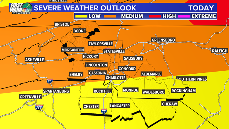
Panovich said Charlotte is in the medium threat for severe weather with a low threat extending into the Columbia area. The primary threat will be damaging winds, but isolated occurrences of hail or a brief tornado could not be ruled out. Periods of heavy rain will also pose a risk to drivers.
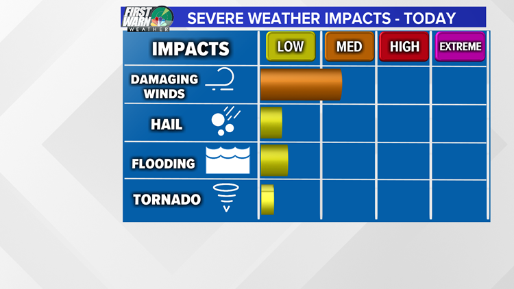
Damaging winds will be the primary threat with storms Monday, but isolated hail or a brief tornado could not be ruled out.
WCNC
The National Weather Service has issued a Severe Thunderstorm Watch for Charlotte, along with the western North Carolina foothills and mountains, through 7 p.m. The watch continues until 9 p.m. for locations to the east of Charlotte.
By 2 p.m., Severe Thunderstorm Warnings had already been issued for some counties in the mountains, including Ashe and Watauga.
Around 3 p.m., a storm in south Charlotte near Pineville prompted the National Weather Service to issue a Severe Thunderstorm Warning. No damage was reported from that storm.
“I still think late-evening is probably the biggest threat because that will maximize the heating of the day also with the arrival of this,” Panovich said.
According to Panovich, these storms should be fast-moving, which means they should not bring flash flood threats. But Panovich said thunderstorms can still produce a lot of rain in a very short amount of time.
The Carolinas should also be alert for some isolated tornadoes as the storm rolls through.
“This has got a little more of a tornado threat than we normally see,” Panovich said. “A tornado threat is really not our highest [threat] — it’s straight-line winds.”
There’s about a 2% chance for an isolated tornado around the Roanoke area and then less than 2% for the Charlotte area, Panovich reports.
Panovich said the Carolinas really need to worry about the wind threat with this storm.
“The wind threat is in the 15% range so that’s by far our highest probability of seeing some damage today,” Panovich said.
Download the WCNC news app to get weather alerts and view radar on-the-go
OTHER STORIES ON WCNC
3-year-old Charlotte girl found, Amber Alert canceled
Rare Pokemon card collection sells for more than $100,000 at auction
3 dead in apparent double murder-suicide in Hickory, police say
Charlotte mom who lost her daughter at 7 weeks flying to Africa to comfort mom who lost baby
Charlotte barber shops launch annual back to school food drive