- Couple accused of creating videos of young girls using hidden cameras at The Woodlands Mall, Hurricane Harbor
- Couple accused of creating videos with hidden cameras at The Woodlands Mall, Hurricane Harbor
- The Texanist: Texas Gets More Tornadoes Than Any Other State, but Don’t Freak Out
- U.S. Supreme Court says Texans can sue state for flood damage
- This is how many hurricanes NC State researchers predict this year
Heavy rain, severe weather tonight could bring us a much milder weekend
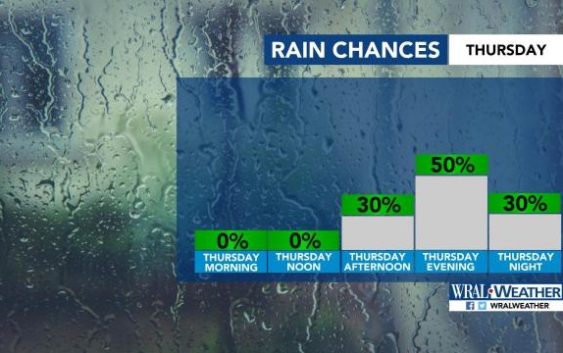
Raleigh, N.C. — Most of the state, including all of central North Carolina, is under a level 1 threat for severe weather for Thursday.
“We should be clear until 2 or 3 p.m.,” said WRAL meteorologist Elizabeth Gardner. After 3 p.m., rain and storms could start to rumble in the Triangle, and severe weather could continue through midnight.
“Some of these storms may be on the stronger side,” Gardner said. “Damaging winds, heavy rain, hail and frequent lightning are possible.”
The storms should peak between 4 p.m. and 9 p.m.
Download the WRAL Weather App to get severe weather alerts.
Thursday will be a hot day leading up to the storms, with a high around 93 degrees. Friday will mimic Thursday, with a dry morning but another chance for afternoon and evening storms. According to Gardner, Friday evening could be wetter than Thursday.
Despite the severe weather expected Thursday, a handful of high schools moved their Friday night football games up one night. That’s because it’s expected to rain Friday night and for most of the weekend.
“It looks like a rainy evening,” Gardner said. “It is not looking good.” Most of central North Carolina will be under a level 1 threat for severe weather on Friday, too, as another front approaches from the south.
While the Triangle will see patchy rain on Saturday and Sunday, North Carolina’s coast will have more rain as a tropical system passes to the east.
At least Saturday and Sunday will be much cooler than the work week, with highs in the low 80s.
A break in the rain should come Sunday, just in time for back-to-school on Monday.
“The first day of school should start out dry, but there might be more rain in the afternoon,” Gardner said.
