- Couple accused of creating videos of young girls using hidden cameras at The Woodlands Mall, Hurricane Harbor
- Couple accused of creating videos with hidden cameras at The Woodlands Mall, Hurricane Harbor
- The Texanist: Texas Gets More Tornadoes Than Any Other State, but Don’t Freak Out
- U.S. Supreme Court says Texans can sue state for flood damage
- This is how many hurricanes NC State researchers predict this year
Tropical Storm Dorian: Puerto Rico Braces for Possible Hurricane
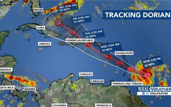
Tropical Storm Dorian was gaining strength in the Atlantic Ocean and moving toward Barbados and the eastern Caribbean on Monday. The storm could develop into a hurricane as it closes in on Puerto Rico and the Dominican Republic this week, forecasters said.
The National Hurricane Center said Monday afternoon that Dorian, the fourth tropical storm of the Atlantic hurricane season, was about 60 miles east-southeast of Barbados. It was moving west at 14 mph, with maximum sustained winds measured at 60 mph.
A hurricane watch was in effect for St. Lucia. And a tropical storm warning was in effect for Barbados, St. Vincent and the Grenadines, where Dorian is expected to dump 3 to 8 inches of rain.
By Wednesday, forecasters said, Dorian could sideswipe southwestern Puerto Rico as a Category 1 hurricane, with winds of at least 74 mph, and then make landfall in the Dominican Republic early Thursday.
Here are some answers about Tropical Storm Dorian and why hurricanes seem to target the Caribbean around this time of year.
— How are islands in the path of the storm preparing?
In Puerto Rico, where memories of the devastation of Hurricanes Irma and Maria in 2017 remain fresh, people raced to big-box retail stores over the weekend. They lined up around the block with shopping carts and emptied some of the stores of supplies, including bottled water.
Generators were also in high demand; the island’s electrical grid remains frail. Puerto Rico’s lead emergency managers met with the new governor, Wanda Vázquez, over the weekend to review disaster plans.
At a news conference on Sunday, officials said they were far better prepared for Dorian than they were before Maria two years ago. “Puerto Rico is ready,” said Zoé Laboy, the governor’s chief of staff.
Still, the preparations have been complicated by politics. The Trump administration said this month that it would delay about $9 billion in disaster prevention funds intended for Puerto Rico and the U.S. Virgin Islands, citing concerns over fiscal management.
And in July, a mass uprising of Puerto Ricans fed up with the poor response to Hurricane Maria, a Category 4 storm, and with the island’s stagnant economy forced the resignation of the governor, Ricardo A. Rosselló.
The National Hurricane Center warned on Monday afternoon that the risk of high winds and rainfall directly affecting Puerto Rico and the Dominican Republic had increased.
In Barbados, Prime Minister Mia Mottley closed schools and government offices across the island nation and asked its 285,000 citizens not to leave their homes. “Stay inside and get some rest,” she said late Sunday. She posted pictures on Twitter showing work crews clearing drains in preparation for the storm, which is expected to soak the island with as much as 4 inches of rain.
— How do hurricanes form?
A hurricane is like an engine, and the difference in temperature between the sea and the upper air is the fuel.
Warm, moist air near the surface rises into the colder air above, and as it does, more surface air rushes in to take its place. As the rising air cools, the moisture in it condenses, forming clouds and releasing heat that accelerates the process. The rotation of the Earth gives the system a nudge, and everything starts to spin, forming a cyclone. — Why do hurricanes usually strike around this time of year?
Hurricane season in the Atlantic, including the Caribbean and the Gulf of Mexico, generally runs from June 1 to Nov. 30 each year, though storms occasionally develop out of season.
The period between mid-August through mid-October is the most active time of the season. The hurricane center said that nearly all of the strongest storms — those in Categories 3 through 5 based on wind speed — occur within that period, as well as a large majority of the less powerful Category 1 and 2 hurricanes.
Surface air temperatures tend to peak near the end of summer, ocean waters remain warm well into the autumn, and there is more moisture in the atmosphere at this time of year, providing the building blocks for a hurricane.
— Why do storms seem to follow familiar paths?
Atlantic tropical storms can form in many different places, from the Cape Verde Islands to the western reaches of the Gulf of Mexico; the likeliest spots vary depending on the month, according to the National Hurricane Center — and so do the tracks they are likely to follow afterward, though some storms may wander far from the average path.
In August and September, the peak part of the season, many storms will follow the east-to-west path that Dorian is currently on.
“That is the time of year when the deep easterly winds across the tropics are strongest,” said Dennis Feltgen, a meteorologist at the hurricane center.
At other times of year, the storms are often slowed and deflected by increasing wind shear — sharp changes in wind direction at different altitudes — and by colder water temperatures, he said.
— How does this season compare with past years?
Dorian is actually just about on schedule: The average arrival date for the fourth named storm of a season is Aug. 23, according to the hurricane center, and Dorian became strong enough to merit a name on Saturday. “They’re pretty much close to on target now,” Feltgen said.
On average, the second storm to reach hurricane strength would be expected to cross that threshold on Aug. 28 — and again, Dorian looks to be right on time.
The first hurricane of 2019 was Barry, which struck the Gulf Coast in July and poured down torrents of rain on an already inundated part of the country, including New Orleans. It has been more than a month since Barry dissipated, which may be why this season may have felt slower than usual. But the National Oceanic and Atmospheric Administration said this month that it still expects as many as 17 named storms before November.
— How is our warming planet affecting hurricanes?
Scientists disagree about some of the ways that climate change affects hurricanes — for instance, whether they will become more frequent.
But researchers see a trend. In a warming world with warmer oceans, there will tend to be a greater temperature difference than before between the sea and the upper air. That adds more fuel, so the engine produces more power, the storms get bigger, and the winds spin faster.
The air will also hold more moisture, which means that the storms will tend to produce more rain. And sea levels are rising, so storm surges are already beginning to start from a higher baseline, making them more destructive.