- Small plane bound for Jamaica with hurricane relief supplies crashes in Florida neighborhood
- Ask the Meteorologist: Did a tornado hit Johnston County Saturday night?
- Demolition begins on flood-damaged homes in Stoney Creek as neighbors await relief
- NC Office of State Fire Marshal aiding in Hurricane Melissa relief efforts
- U.S.-based aid groups rush to get supplies into storm-battered Jamaica after Hurricane Melissa
Hurricane Dorian track shifts towards Carolinas

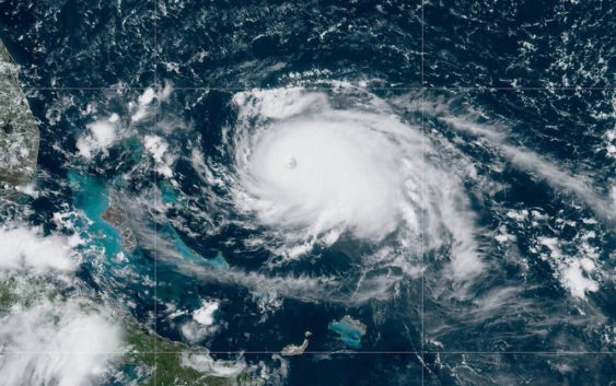
CHARLOTTE, N.C. — Here’s the latest on Hurricane Dorian
As of the 11 a.m. et update from the National Hurricane Center
LOCATION: 415 MI E OF WEST PALM BEACH FLORIDA
MAXIMUM SUSTAINED WINDS: 150 MPH
MOVEMENT: W AT 8 MPH
“Dorian is now a major hurricane,” the National Hurricane Center said Friday.
Dorian is a Category 4 hurricane with sustained winds of 150 mph. On Tuesday, the major hurricane was precluded to make landfall in Florida as a Category 4.
A notable change overnight, looks like Dorian will ride off the Florida coast and turn up along the South Carolina coast by late Wednesday into Thursday as a Category 3 hurricane, according to the National Hurricane Center.
The storm is moving west at 8 mph. It is 415 miles east of West Palm Beach, Florida.
A Hurricane Warning is in effect for Northwestern Bahamas. A Hurricane Watch is in effect for Andros Island
On this track, the core of Dorian should move over the Atlantic well north of the southeastern and central Bahamas Friday night and Saturday, be near or over the northwestern Bahamas on Sunday, and be near the Florida east coast late Monday.
North Carolina has issued a state of emergency ahead of potential impacts from Hurricane Dorian. The governor of South Carolina said he is monitoring the situation closely and may also issue a state of emergency.
Swells are likely to begin affecting the east-facing shores of the Bahamas, the Florida east coast, and the southeastern United States coast during the next few days. These swells are likely to cause life-threatening surf and rip current conditions.
Flooding will be a major concern for Florida. Rainfall rates, combined with storm surge, could result in life-threatening flash floods.
It is still not known exactly where the storm will make landfall but forecasts believe it will likely be in Florida. The uncertainty, which is commonly portrayed in the forecast track’s “cone of uncertainty,” will shrink as the storm moves closer to shore.
RELATED: 5 Things to Know About Hurricane Dorian
Panovich said everyone living along the Southeast coast should be paying attention. The track could shift.
“Residents in these areas should ensure that they have their hurricane plan in place and not focus on the exact forecast track of Dorian’s center,” according to the National Hurricane Center.
Regardless of where the storm ultimately makes landfall, heavy rain can be expected in across the Southeast next week, including in portions of North Carolina, South Carolina, Georgia, and Florida.
RELATED: Airlines offer travel waivers as Dorian reaches hurricane strength
RELATED: Person struck by lightning in Marion, numerous tress toppled during storms
RELATED: Lightning strikes kill 5, injure over 100 in eastern Europe’s Tatra Mountains
RELATED: Extensive tree damage in Statesville after severe weather
RELATED: Two rescued from flooded car during Charlotte storms