- Couple accused of creating videos of young girls using hidden cameras at The Woodlands Mall, Hurricane Harbor
- Couple accused of creating videos with hidden cameras at The Woodlands Mall, Hurricane Harbor
- The Texanist: Texas Gets More Tornadoes Than Any Other State, but Don’t Freak Out
- U.S. Supreme Court says Texans can sue state for flood damage
- This is how many hurricanes NC State researchers predict this year
Hurricane Dorian packs winds of 175 mph as it nears Fla.; greater risk to Ga., Carolinas
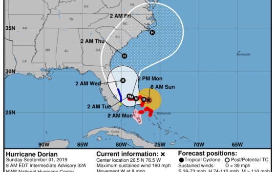
A tortuously slow-moving hurricane Dorian continues to crawl toward the northwestern Bahamas, threatening the tiny islands with devastating 150-mph winds and drowning storm surge.
The storm, which has maintained Category 4 strength for more than 24 hours, is about 255 miles east of West Palm Beach, and about 70 miles east of Great Abaco Island.
With hurricane-force winds extending out 30 miles and tropical-storm-force winds extending 105, the first burst of Dorian’s assault is already upon Marsh Harbour and Coopers Town in Great Abaco.
A tropical storm warning has now been issued for areas of South Florida from Sebastian Inlet to Deerfield Beach.
A tropical storm warning means winds of above 39 mph are expected in an area within 36 hours.
A tropical storm watch has been issued for north of Golden Beach to Deerfield Beach.
Additional tropical storm watches and warnings may be added for the east coast of Florida today.
While the official forecast track changed little overnight, hurricane center forecasters said some recent model runs have shifted Dorian’s path west, putting Florida at a higher risk.
“Although the exact NHC track forecast lies east of the Florida peninsula, a track closer to the coast or even a landfall remain a possibility,” said NHC senior hurricane specialist Dan Brown in his Saturday 11 p.m. forecast.