- The Texanist: Texas Gets More Tornadoes Than Any Other State, but Don’t Freak Out
- U.S. Supreme Court says Texans can sue state for flood damage
- This is how many hurricanes NC State researchers predict this year
- NC State researchers predict above-average hurricane season
- Supreme Court rules in favor of property owners suing Texas over flood damage
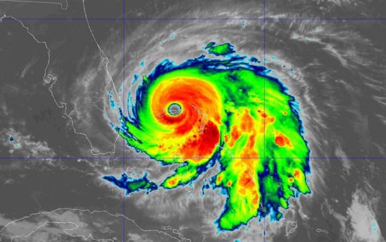
Hurricane Dorian causes catastrophic damage on Bahamas as powerful category 5 storm
CHARLOTTE, N.C. — Here’s the latest on Hurricane Dorian
As of the 5 a.m. ET update from the National Hurricane Center
LOCATION: ABOUT 60 MILES EAST OF FREEPORT GRAND BAHAMA ISLAND, ABOUT 115 MILES EAST OF WEST PALM BEACH, FLORIDA
MAXIMUM SUSTAINED WINDS: 165 MPH
MOVEMENT: W AT 1 MPH
On Sunday, the National Hurricane Center declared Hurricane Dorian as a Category 5 hurricane. This is a powerful and dangerous catastrophic storm.
At 11 p.m. Sunday, the National Hurricane Center said Hurricane Dorian, which is described as a catastrophic hurricane, made landfall on the eastern end of Grand Bahama Island.
Maximum winds from Dorian are sustained at 165 mph with higher gusts. According to the National Hurricane Center, hurricane-force winds extend outward up to 45 miles from the center, while tropical-storm-force winds extend about 140 miles from Dorian’s center.
Dorian is crawling toward the west at only 1 mile per hour, according to the National Hurricane Center. Slower westward to west-northwestward motions are expected to continue for a day or two, followed by a gradual turn toward the northwest.
Currently, the core is expected to continue to pound Great Abaco and Grand Bahama islands overnight and through much of Monday. The hurricane is expected to move ‘dangerously close’ to Florida east coast late Monday through Wednesday evening.
There is an increasing likelihood of strong winds and dangerous storm surge along the Carolina coasts as well as the Georgia coast later in the week.
Sunday evening, South Carolina Gov. Henry McMaster issued mandatory evacuations for people living along the coastline of South Carolina, as Hurricane Dorian is expected to affect the state by midweek. There will also be school closings, and a lane reversals of Interstate 26.
RELATED: Mandatory evacuations ordered for entire South Carolina coast, lane reversals for I-26
North Carolina issued a state of emergency ahead of potential impacts from Hurricane Dorian. South Carolina Governor Henry McMaster also declared a state of emergency because of the threat of Hurricane Dorian.
Later on Saturday, the city of Charleston declared a state of emergency as well, to ensure the city is fully prepared for emergency operations. The Municipal Emergency Operations Center will be activated Sunday at 8 a.m. and will remain open as needed throughout the storm.
According to the National Weather Service, there is an increasing risk of strong winds and dangerous storm surge along the coasts of Georgia, South Carolina and North Carolina during the middle of the week.
The National Hurricane Center said slow weakening is forecast, but fluctuations in intensity could occur over the next couple of days. Nevertheless, Dorian is expected to stay a powerful hurricane over the next few days, according to the NHC.
A Hurricane Warning is in effect for Northwestern Bahamas excluding Andros Island, as well as from Jupiter Inlet to the Volusia/Brevard County Line.
A Hurricane Watch is in effect for Volusia/Brevard County Line to the Mouth of the St. Mary’s River, North of Deerfield Beach to Jupiter Inlet, and Andros Island.
A Tropical Storm Warning is in effect for North of Deerfield Beach to Jupiter Inlet, and a Tropical Storm Watch is in effect for North of Golden Beach to Deerfield Beach and Lake Okeechobee.
A Storm Surge Warning was issued from Lantana to the Volusia/Brevard County Line, and a Storm Surge Watch was issued from the Volusia/Brevard County Line to the Mouth of the St. Mary’s River, as well as from North of Deerfield Beach to Lantana.
The core of Dorian is expected to be near or over part of the northwestern Bahamas on Sunday, then move closer to the Florida east coast late Monday through Tuesday.
On this track, the core of extremely dangerous Hurricane Dorian is expected to continue to pound Great Abaco and Grand Bahama islands Sunday night and Monday.
The hurricane is expected to move dangerously close to the Florida east coast late Monday through Tuesday night.
Swells are likely to begin affecting the east-facing shores of the Bahamas, the Florida east coast, and the southeastern United States coast during the next few days. These swells are likely to cause life-threatening surf and rip current conditions.
Flooding will be a major concern for Florida. Rainfall rates, combined with storm surge, could result in life-threatening flash floods. Dorian is expected to produce 12 to 24 inches, isolated 30 inches, of rainfall totals for the Northwestern Bahamas alone.
NHC says Dorian is expected to produce 5 to 10 inches, isolated 15 inches, for the Coastal Carolinas.
RELATED: 5 Things to Know About Hurricane Dorian
Panovich said everyone living along the Southeast coast should be paying attention. The track could shift.
“Residents in these areas should ensure that they have their hurricane plan in place and not focus on the exact forecast track of Dorian’s center,” according to the National Hurricane Center.
RELATED: Airlines offer travel waivers as Dorian reaches hurricane strength
RELATED: Person struck by lightning in Marion, numerous tress toppled during storms
RELATED: Lightning strikes kill 5, injure over 100 in eastern Europe’s Tatra Mountains
RELATED: Extensive tree damage in Statesville after severe weather
RELATED: Two rescued from flooded car during Charlotte storms