- U.S. Supreme Court says Texans can sue state for flood damage
- This is how many hurricanes NC State researchers predict this year
- NC State researchers predict above-average hurricane season
- Supreme Court rules in favor of property owners suing Texas over flood damage
- Texas Land Commissioner announces extension for Houston to distribute federal relief funds for Hurricane Harvey
7 PM Update: Hurricane Dorian lashing Florida coast, eyeing Carolina landfall
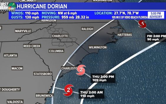
CHARLOTTE, N.C. — Hurricane Dorian is moving nearly parallel to the Florida coastline as it moves north at 6 mph. Despite its slow movement to the north, this is the fastest the storm has moved in more than a day.
“The eyewall of Dorian continues to move away from Grand Bahama Island. However, dangerous winds and life-threatening storm surge will continue over that island through this evening,” the National Hurricane Center said.
The powerful storm was parked over the Bahamas for over 24 hours before starting to crawl toward the northwest.
According to the National Hurricane Center, Dorian is now moving northwest at 6 mph. Dorian is expected to stay offshore as it moves along the Florida coast. The storm is “lashing the east coast of Florida,” the National Hurricane Center said.
The storm is still packing sustained of 110 mph with higher gusts. According to the National Hurricane Center, hurricane-force winds extend outward up to 45 miles from the center, while tropical-storm-force winds extend about 150 miles from Dorian’s center.
A sustained wind of 43 mph and a wind gust of 57 mph were recently reported at a weather station at Sebastian Inlet. At Indian River, Florida, a sustained wind of 38 mph and a wind gust of 55 mph were recently reported.
Hurricane Dorian is expected to reach the coast of South Carolina late Wednesday into Thursday.
First Warn chief meteorologist Brad Panovich says the biggest concerns for the Carolinas will be along the coast with the combination of heavy rain, wind and storm surge. Panovich said there is a growing consensus among computer models tracking where Dorian will head next.
“Forecast models are so tightly clustered it’s insane,” Panovich said. “I’m starting to worry about eastern North Carolina, that’s where the concern comes in because it’s just too close to call. We could see a landfall in North Carolina.”