- Couple accused of creating videos of young girls using hidden cameras at The Woodlands Mall, Hurricane Harbor
- Couple accused of creating videos with hidden cameras at The Woodlands Mall, Hurricane Harbor
- The Texanist: Texas Gets More Tornadoes Than Any Other State, but Don’t Freak Out
- U.S. Supreme Court says Texans can sue state for flood damage
- This is how many hurricanes NC State researchers predict this year
Live Blog: Hurricane Dorian still a Category 3, slowly beginning to crawl away from Grand Bahama
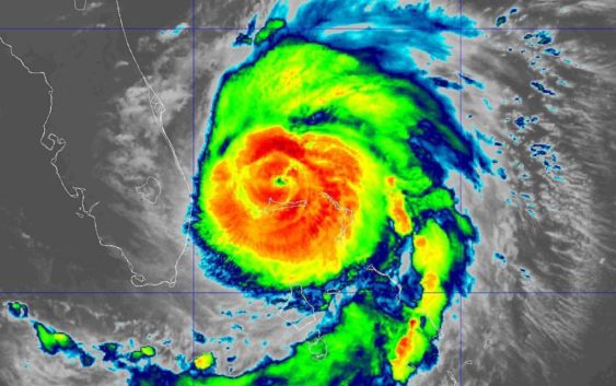
CHARLOTTE, N.C. — Hurricane Dorian is a dangerous hurricane headed towards the Southeast coastline. This is a live blog from the digital staff at WCNC.com with continuous updates on the storm, its impact, and on-going developments.
Tuesday, September 3
10 a.m.
Not much has changed with the 10 a.m. update from the National Hurricane Center. Hurricane Dorian still has sustained winds of 115 mph and is now about 100 miles east-northeast of West Palm Beach, Florida. The NHC said wind gusts of tropical storm force are now occurring along the Treasure Coast of Florida.
9: a.m.
The National Hurricane Center says Dorian is still trekking northwestward at a slow 1 mph. The storm now has sustained winds of 115 mph, still keeping the storm at a very powerful Category 3.
Hazards associated with this storm include wind gusts of 140 mph, storm surge 10-15 feet above normal tide levels and extreme flooding.
8 a.m.
The National Hurricane Center says Dorian is now beginning to “inch northwestward” as it pounds Grand Bahama Island. The storm has sustained winds of 120 mph and is moving northwest at 1 mph.
7 a.m.
Larry Sprinkle updates the conditions on Dorian, which is still stationary over the Bahamas. The Charlotte area can expect minimal impact, but the Carolina coast, especially in areas around Charleston, may see 4-7 feet of storm surge from Dorian.
6 a.m.
More than 1,300 flights have been canceled nationwide due to Dorian. According to FlightAware, a total of 50-100 canceled flights would be typical in the U.S. Orlando topped the list for cancellations with 694 combined flights.
5 a.m.
Dorian remains stationary over the Bahamas with 120 mph winds. The National Hurricane Center says the Category 3 storm will make its turn northward later Tuesday morning. It is expected to reach the South Carolina coast late Wednesday into Thursday.
2 a.m.
Hurricane Dorian is still stationary over Grand Bahama Island. The storm has been downgraded to Category 3 status with sustained winds of 120 mph as it continues to pummel the Bahamas.
11:15 p.m.
Currently, North Carolina has the largest land area in the Monday 11 p.m. forecast cone for Hurricane Dorian. At this time, no part of Florida is in the forecast cone.
11:00 p.m.
Dorian is still stationary and continues to pummel Grand Bahama Island, according to the National Hurricane Center. It has maximum sustained winds of 130 mph and is about 30 miles north-northeast of Freeport Grand Bahama Island.
The Storm Surge Warning was extended northward from Altamaha Sound, Georgia to the Savannah River.
Chief Meteorologist Brad Panovich says there will likely be landfall in eastern North Carolina on Thursday.
10:00 p.m.
A 24-hour loop of Hurricane Dorian shows the total distance traveled of the center of the eye was just around 30 miles.
9:00 p.m.
Hurricane Dorian is located 25 miles Northeast of Freeport Grand Bahama Island and is still considered to be stationary.
RELATED: Dorian isn’t moving because the upper atmosphere is too calm
8:00 p.m.
Hurricane Dorian remains “nearly stationary” as it continues to pummel Grand Bahama Island. Dorian has maximum sustained winds of 140 mph and is about 25 miles Northeast of Freeport Grand Bahama Island.
6:50 p.m.
Chief Meteorologist Brad Panovich releases past 7-day life cycle of Hurricane Dorian.
“This is about as consistent a track as I’ve seen in a while,” Chief Meteorologist Brad Panovich said.
6:00 p.m.
Hurricane Dorian has maximum sustained winds of 145 miles per hour, and remains nearly stationary while 30 miles Northeast of Freeport Grand Bahama Island.
5:50 p.m.
Bahamas Prime Minister Hubert Minnis says at least five people have died in the Abaco Islands as Hurricane Dorian continues to pound the region as a Category 4 storm.
RELATED: At least 5 dead in the Bahamas as Hurricane Dorian triggers massive flooding
5:35 p.m.
NBC Charlotte’s Savannah Levins is at Carolina Beach. No mandatory evacuations have been put in place yet. Some people there told NBC Charlotte they actually evacuated to the North Carolina beach from South Carolina.
5:00 p.m.
Hurricane Dorian is considered ‘nearly stationary,’ and has maximum sustained winds of 145 mph. A Storm Surge Watch and Hurricane Watch have been extended northward to South Santee River in South Carolina.
4:00 p.m.
NC Governor Roy Cooper spoke on coastal impact and ongoing preparations for Dorian. Gov. Cooper urged everyone to make plans for possible evacuation and to include their pets in plans. Gov. Cooper said he has asked President Trump for a Federal Disaster Declaration so the state can get help if needed.
“We have to respect the threat that Dorian brings,” Gov. Cooper said.
3:40 p.m.
Chief Meteorologist Brad Panovich said Hurricane Dorian is now drifting North and is very slow. As it moves North, Panovich said it’s going to start experiencing a little bit of wind shear. It’s likely to be a Category 3 or higher for the next several days, Panovich said.
3:05 p.m.
Dare County Emergency Management issued a mandatory evacuation for all visitors beginning Tuesday at 12 p.m. A mandatory evacuation for all Dare County, NC residents begins at 6 a.m. Wednesday.
2:15 p.m.
South Carolina officials say the lane reversal evacuations on Interstate 26 began early Monday. Scheduled to begin at Noon, all lanes opened to westbound-only traffic at 10:30 a.m.
2 p.m.
Hurricane Dorian has 150 mph sustained winds. The storm is located 25 miles northeast of Freeport, Grand Bahama Island.
1 p.m.
“This is a life-threatening situation,” the National Hurricane Center is reiterating as the storm continues to over over the northern Bahamas. They issued a special bulletin. “Residents on Grand Bahama Island should not leave their shelter when the eye passes over, as winds will rapidly increase on the other side of the eye. Residents in the Abacos should continue to stay in their shelter until conditions subside later today.”
Degraded from a category 5 to a category 4, the storm still poses a catastrophic threat. Maximum sustained winds of 155 mph with gusts up to 190 mph.
12:30 p.m.
The University of North Carolina Wilmington canceled classes for the week and has ordered students and staff to evacuate. All students must be evacuated from campus by 5:00 p.m. on Tuesday.
RELATED: Mandatory Evacuation of Campus Ordered, Classes Canceled for the Week at UNC Wilmington
Noon
Evacuations in coastal South Carolina have begun. Drivers can use all lanes of Interstate 26 from Charleston to Columbia in the westbound direction. Eastbound lanes have been reserved to allow westbound flowing traffic.
RELATED: State troopers begin lane reversals on I-26 in South Carolina ahead of Hurricane Dorian
11 a.m.
Hurricane Dorian is a category 4 storm with maximum sustained winds of 155 mph. Despite no longer being a category 5 storm, the hurricane remains extremely dangerous.
It is moving west at only 1 mph. The storm is all but stalled over the northern Bahamas, where it is causing storm Surge 18 to 23 feet above normal tide levels with higher destructive waves.
The storm is inching towards the coastline of Florida. Later today, the storm is expected to begin a slow turn to the north. Exactly where and when that happens is still not known and will greatly effect its position as it heads towards Georgia, South Carolina, and North Carolina.
The eye of the storm could still make landfall anywhere along the Southeast coast.
By Wednesday morning, the storm will be near Jacksonville, Florida.
By Thursday morning, the eye of the storm will be near Savannah, Georgia, and Hilton Head, South Carolina.
By Friday morning, the eye of the storm will be near the Outer Banks of North Carolina.
Tropical-storm force winds will arrive ahead of the eye. As the eye nears, winds will increase to near-category 2 strength with winds of at least 96 mph.
Regardless of wind strength, the storm is expected to cause dangerous flooding along the coast. Heavy rain and strong storm surge will cause flooding.
Coastal Georgia and South Carolina are being evacuated ahead of the storm beginning today.
RELATED: Mandatory evacuations ordered for entire South Carolina coastline, lane reversals for I-26
8 a.m. Monday, September 2
Hurricane Dorian has stalled 35 miles east of Freeport, Bahamas. It has sustained winds of 165 mph. It is causing an extremely dangerous situation in the north Bahamas.
11 p.m. Sunday, September 1
Hurricane Dorian is a category 5 storm with maximum sustained winds of 180 mph. Is is located over the northern Bahamas and only moving west at 6 mph.
A turn to the north is expected near Florida’s coastline beginning Monday.
The storm is still expected to travel north along the Southeast coast, eventually bringing strong wind and rain to Georgia, South Carolina, and North Carolina.
Evacuations will begin Noon Monday in South Carolina.
Total rainfall forecasted for the coast ranges between 7 and 10 inches.
6:30 p.m. Sunday, September 1
Evacuations are being ordered along the coast of South Carolina ahead of Hurricane Dorian.
Beginning at Noon Monday, all lanes of Interstate 26 between Charleston and Columbia will be available to westbound traffic only. Lanes normally used for eastbound traffic will be closed to eastbound traffic and used by westbound traveling evacuees.