- Habitat for Humanity helping Rock Hill residents assess, clean up storm damage. They are also seeking volunteers
- Smokehouse Creek wildfire victims line up lawsuits against utility
- Will Mexico wildfires impact Houston's air quality?
- The worst tornadoes in North Carolina History
- Hurricane-proof your NC home: Essential steps to weather the storm
Tropical Storm Fernand expected to form in Gulf of Mexico by tonight
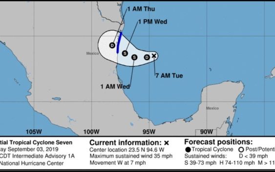
HOUSTON — The National Hurricane Center is issuing advisories on potential tropical cyclone number seven, which is located in the Gulf of Mexico.
As of Tuesday morning the disturbance was located about 200 miles east of La Pesca, Mexico and moving west at 7 mph.
In Houston, we don’t have to worry much about it as the forecast track has it continuing westward. But our friends and neighbors in South Texas and in Mexico will want to keep a close eye on it.
RELATED: Forecasters now monitoring four other tropical disturbances
The system is expected to become a tropical storm by Tuesday night, according to the NHC. KHOU 11 Meteorologist Chita Craft says because this would be cyclone number seven, it will be called Fernand when it becomes a tropical storm.
As of the 7 a.m. NHC update Tuesday maximum sustained winds were at 35 mph.
What does this mean for Texas?
For Houston, not much. But in South Texas and the lower Texas Coast they can expect two to four inches of rain through Friday with the potential for flash flooding. Mexico will get the worst of the weather with six to 12 inches of rain expected – the highest in the Sierra Madre Oriental of Tamaulipas and Nuevo Leon. Through Friday some parts of Mexico could get 15 inches of rain.

Tropical storm developing in the Gulf of Mexico
KHOU 11
7 a.m. advisory from NHC:
At 700 AM CDT (1200 UTC), the disturbance was centered near latitude 23.5 North, longitude 94.6 West. The system is moving toward the west near 7 mph (11 km/h) and this motion is expected to continue today. A motion toward the west or west-northwest is forecast on Wednesday. This motion could bring the system near or over the coast of northeastern Mexico late Wednesday.
Maximum sustained winds are near 35 mph (55 km/h) with higher gusts. Some strengthening is forecast is forecast during the next 48 hours, and the disturbance is expected to become a tropical cyclone later today and become a tropical storm by tonight. Shower and thunderstorm activity has been increasing in organization this morning, and the low is likely to become a tropical depression or a tropical storm later today or tonight.
* Formation chance through 48 hours…high…near 100 percent
* Formation chance through 5 days…high…near 100 percent
The estimated minimum central pressure is 1004 mb (29.65 inches).
RELATED: Florida officer rescues puppy ahead of Hurricane Dorian, names her ‘Dory’
RELATED: 1,400 more flights canceled Tuesday as Hurricane Dorian moves toward U.S.
RELATED: Hurricane Dorian weakens to Category 3 but still stalled near Bahamas