- The Texanist: Texas Gets More Tornadoes Than Any Other State, but Don’t Freak Out
- U.S. Supreme Court says Texans can sue state for flood damage
- This is how many hurricanes NC State researchers predict this year
- NC State researchers predict above-average hurricane season
- Supreme Court rules in favor of property owners suing Texas over flood damage
2 p.m. update: Eye of Hurricane Dorian now east of Jacksonville, FL
CHARLOTTE, N.C. — Millions of people are boarding up and evacuating as Hurricane Dorian continues to move northwest toward the Carolina coast Wednesday morning.
First Warn chief meteorologist Brad Panovich said Dorian will make “significant impacts” on the Carolina coasts starting Wednesday night through early Friday. The National Hurricane Center expects the center of Dorian to move over the Carolinas early Thursday.
As of 2 p.m., Dorian has 105 mph sustained winds with the eye of the storm now east of Jacksonville, Fla.
A slow weakening is expected during the next few days. However, Dorian is expected to remain a powerful hurricane during this time.
The powerful storm was parked over the Bahamas for over 24 hours before starting to crawl toward the northwest. Dorian is expected to stay offshore as it moves along the Florida coast. The storm is “lashing the east coast of Florida,” the National Hurricane Center said.
The storm is still packing sustained of 105 mph with higher gusts. According to the National Hurricane Center, hurricane-force winds extend outward up to 60 miles from the center, while tropical-storm-force winds extend about 175 miles from Dorian’s center.
Panovich says the biggest concerns for the Carolinas will be along the coast with the combination of heavy rain, wind and storm surge. First Warn Forecaster Larry Sprinkle said the most dangerous part of a storm is the surge.
Panovich said there is a growing consensus among computer models tracking where Dorian will head next.
“Forecast models are so tightly clustered it’s insane,” Panovich said. “I’m starting to worry about eastern North Carolina, that’s where the concern comes in because it’s just too close to call. We could see a landfall in North Carolina.”
WCNC has a new app. Click here to download it
Hurricane Dorian latest conditions
As of the 2 p.m. ET advisory from the National Hurricane Center
LOCATION: ABOUT 115 MILES EAST-NORTHEAST OF JACKSONVILLE, FL
MAXIMUM SUSTAINED WINDS: 105 MPH
MOVEMENT: NORTH-NORTHWEST AT 9 MPH
Panovich says confidence in the models means forecasters can be more focused on the impacts when the storm does eventually reach the Carolina coast.
The high risk along the coast could result in 5-10 feet of storm surge, 10-15 inches of rain and 50-75 mph winds as the storm churns north.
There is some good news for those that are inland, as Panovich says Dorian won’t be a major wind event. The impacts will be spread further out, but the highest impact will be on the immediate coast.
Panovich says the storm will cause sound-side flooding when it reaches the Outer Banks and affect areas that were devastated by Hurricane Florence, such as New Bern and Havelock.
Never miss an alert. Download the new WCNC app today
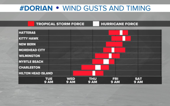
Forecast timing

WCNC
First Warn meteorologist Chris Mulcahy said reported the outer bands of Dorian are moving closer to the shoreline in Georgia and South Carolina with rain expected in Charleston Wednesday morning. The heaviest rain is expected to reach Charleston Wednesday evening through Thursday morning.
The storm will move north up the coast and reach Myrtle Beach by Thursday night into Friday. Dorian is expected to reach the Outer Banks Friday morning, with a possible landfall coming near Hatteras as some of the models start to disagree on the storm’s exact track.
Sunday evening, South Carolina Gov. Henry McMaster issued mandatory evacuations for people living along the coastline of South Carolina, as Hurricane Dorian is expected to affect the state by midweek. State troopers began the reversal of all lanes on I-26 out of Charleston Monday morning with evacuations taking effect at 12 p.m.
“Water, water, water is our concern,” said Panovich, urging anyone told to evacuate to listen. “You run from the water, you hide from the wind.”
RELATED: Mandatory evacuations ordered for entire South Carolina coast, lane reversals for I-26
North Carolina issued a state of emergency ahead of potential impacts from Hurricane Dorian. South Carolina Governor Henry McMaster also declared a state of emergency because of the threat of Hurricane Dorian.
Later on Saturday, the city of Charleston declared a state of emergency as well, to ensure the city is fully prepared for emergency operations. The Municipal Emergency Operations Center will be activated Sunday at 8 a.m. and will remain open as needed throughout the storm.
According to the National Weather Service, there is an increasing risk of strong winds and dangerous storm surge along the coasts of Georgia, South Carolina and North Carolina during the middle of the week.
The National Hurricane Center said slow weakening is forecast, but fluctuations in intensity could occur over the next couple of days. Nevertheless, Dorian is expected to stay a powerful hurricane over the next few days, according to the NHC.
INTERACTIVE MAP: Track Hurricane Dorian
Watches and warnings
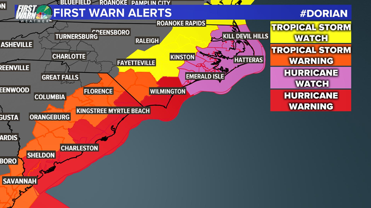
WCNC
WATCHES AND WARNINGS
A Storm Surge Warning is in effect for:
- North of Port Canaveral FL to the North Carolina/Virginia border
- Pamlico and Albemarle Sounds
- Neuse and Pamlico Rivers
A Storm Surge Watch is in effect for:
- North Carolina/Virginia border to Poquoson VA, including Hampton Roads
A Hurricane Warning is in effect for:
- North of Savannah River to the North Carolina/Virginia border
- Albemarle and Pamlico Sounds
A Hurricane Watch is in effect for
North of Ponte Vedra Beach FL to Savannah River
A Tropical Storm Warning is in effect for
Volusia/Brevard County FL line to Savannah River
A Tropical Storm Watch is in effect for
The North Carolina/Virginia border to Chincoteague VA
Chesapeake Bay from Smith Point southward
RELATED: 5 Things to Know About Hurricane Dorian
“Residents in these areas should ensure that they have their hurricane plan in place and not focus on the exact forecast track of Dorian’s center,” according to the National Hurricane Center.
RELATED: Airlines offer travel waivers as Dorian reaches hurricane strength
RELATED: Person struck by lightning in Marion, numerous tress toppled during storms
RELATED: Lightning strikes kill 5, injure over 100 in eastern Europe’s Tatra Mountains
RELATED: Extensive tree damage in Statesville after severe weather
RELATED: Two rescued from flooded car during Charlotte storms