- The Texanist: Texas Gets More Tornadoes Than Any Other State, but Don’t Freak Out
- U.S. Supreme Court says Texans can sue state for flood damage
- This is how many hurricanes NC State researchers predict this year
- NC State researchers predict above-average hurricane season
- Supreme Court rules in favor of property owners suing Texas over flood damage
Heavy rain could cause flash flood issues this week in Houston area
HOUSTON — Rainy Days and Mondays. And Tuesdays, Wednesdays and Thursdays, too. That pretty much sums up our weather this week.
The unusually hot weather this deep into September has only exacerbated the dry conditions that continue to plague the area. However, a big drink of water is on the way and we may end up with too much of a good thing as flash flooding will be possible around the area.
A tropical wave in the central gulf is moving towards the Texas coast. While the National Hurricane Center currently gives this a 10% of development over the next few days, there is almost no model support for development.
Even if it did develop, which it’s not expected to, the results would be the same: heavy rain.
One thing there is model support for is an on-slot of the moisture currently sitting south of Louisiana. Take a look at the model projections below.
Keep in mind that this model continues to waffle back and forth with how much rain can be expected but the general consensus is 1-3 inches with isolated amount greater than 4 inches. As we know, it doesn’t take much for certain side streets and low-lying sections of freeway to quickly pond. While there is no flash flood watch in effect currently, that may change over the next day or two.

KHOU
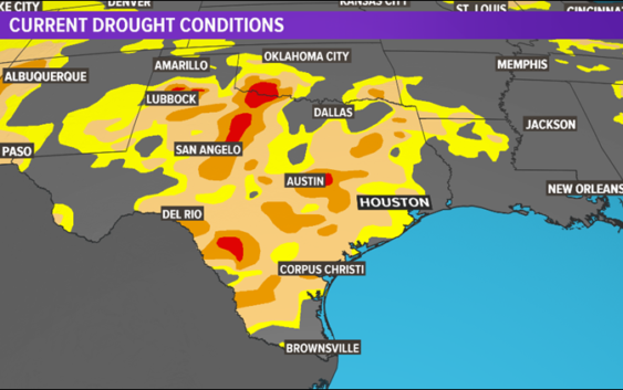
It’s no secret that things are dry around here. It’s not just southeast Texas, either. In-fact, the entire state is suffering from abnormally dry conditions; and some areas even seeing ‘severe’ drought conditions, as seen in red.
We’ll continue to keep you updated as the rain begins to work its way in. At this time, we’re not looking for major problems but again, some isolated flash flooding could be an issue Wednesday and Thursday.
Timeline:
Monday: We will likely wake up to some coastal showers that will work their way through the coastal areas. By the afternoon and the heat of the day, we could see these move into the I-10 corridor. Chance of rain Monday stands at 30%.
Tuesday: The rain will become even more widespread. Like Monday, we’ll start with some coastal showers that will progress inland as we get into the afternoon. This time, even the inland counties are likely to get in on some of the action. Chance of rain stands at 50%.
Wednesday and Thursday: both days should see widespread coverage of showers and thunderstorms. Locally heavy rainfall will be possible with some rain rates reaching 1-2 inches per hour. All counties, especially south of I-10 will be prone to localized flooding and flash flooding. Some areas could tally 2 to 3 inches and some areas even more than that. Chance of rain both days is 70%.
Friday: We’ll see the bulk of the rain coming to an end but we’ll still have enough left over moisture to spark more showers and storms around the area. Chance of rain is 40%.
By the weekend, it should be drier but still a slight chance of showers will remain.
Cold Front:
Hate to bury the lead here but the computer models have all but done away with our strong cold front at the end of the month. The exceedingly hot September, even by Houston standards, looks to continue. I’m sorry. Nobody wants cooler weather more than me. I’ll let you know if I see anything promising but right now, more of the same is in the forecast.