- The Texanist: Texas Gets More Tornadoes Than Any Other State, but Don’t Freak Out
- U.S. Supreme Court says Texans can sue state for flood damage
- This is how many hurricanes NC State researchers predict this year
- NC State researchers predict above-average hurricane season
- Supreme Court rules in favor of property owners suing Texas over flood damage
Houston weather timeline: Flash Flood Watch issued for Houston area
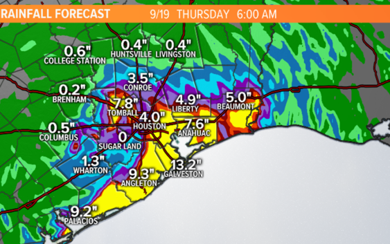
HOUSTON — Very heavy rain is on the way for southeast Texas as a slow moving tropical wave works its way towards the Texas coast. The onslaught of tropical rains moving at a snail’s pace could spell flood issues over the next few days.
A Flash Flood Watch has been issued for Brazoria, Chambers, Fort Bend, Harris, Liberty, Matagorda, Galveston and Wharton counties from 1 p.m. Tuesday until Wednesday afternoon.
RELATED: How the City of Houston is preparing for the rainy week ahead
RELATED: 5 ways to prepare for potential flooding
Tuesday Morning
Heaviest rain on the Galveston and upper Texas coast. Flood threat stays low. Watch for minor flooding in low spots at times of high tide near the coast.
Tuesday Afternoon
Scattered tropical downpours move inland across southeast Texas and Houston. Storms should be moving quickly but may cause some isolated street flooding. Flood threat still low.
Tuesday night and Wednesday morning
Flash flooding becomes a larger threat as the disturbance moves onshore. Rainfall rates of 2 to 4 inches per hour and the threat for ‘training’ increases. Flood threat moderate.
Wednesday night and Thursday morning
At this point the ground across Houston and southeast Texas will become saturated. Any heavy downpours that develop and train across the area will quickly spark the threat for flash flooding on roads, creeks and bayous. Rivers will have to be closely monitored as well. Flash flood threat high.
Thursday afternoon and evening
Some computer models have the system and the rain moving north out of the Houston area Thursday evening. Others have it lingering through Thursday evening until finally exiting on Friday. For now I’ll leave the flash flood threat elevated through Thursday night.
If you live near a low lying area or spot that is prone to flooding stay close to the weather forecast and monitor the radar. Download the KHOU 11 App so you’ll get all the latest updates from our weather and news department and be ready to take action if necessary.
Be sure to watch the weather at least once a day on KHOU 11 News and stay weather aware with us as we enter the busy time of hurricane season.
What to Expect:
Rain and possibly a lot of it. As mentioned, computer models have drastically increased the amount of rain we could potentially see with this slow moving tropical wave.
The KHOU weather team is forecasting up to 9 inches of rain for a large swath of southeast Texas but some areas could see totals over 12 inches.
While the ground is dry and much of Texas is in the midst of mild drought conditions, we’ll be able to absorb a lot of the water initially. However with rain rates as high as 2 to 3 inches per hour, that could quickly lead to run off and quick ponding of usual suspect spots including low-lying roads and freeways (think feeders and I-45 north at Main St) along with other area side streets.
As we know well here in Houston, tropical waves often have a trick or two up their sleeve and while we’re confident it will rain, totals will be a watch and wait kind of deal. Certainly 8 to 10 inches with isolated amounts over a foot can’t be ruled out.
By the weekend, it should be drier but still a slight chance of showers will remain.