- Couple accused of creating videos of young girls using hidden cameras at The Woodlands Mall, Hurricane Harbor
- Couple accused of creating videos with hidden cameras at The Woodlands Mall, Hurricane Harbor
- The Texanist: Texas Gets More Tornadoes Than Any Other State, but Don’t Freak Out
- U.S. Supreme Court says Texans can sue state for flood damage
- This is how many hurricanes NC State researchers predict this year
Flash Flood Watch continues: Tropical Depression Imelda moving east of Houston
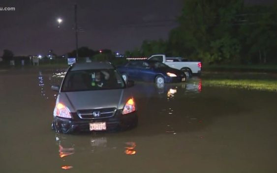
HOUSTON — Imelda weakened to a tropical depression shortly after making landfall in the Houston area. The heaviest rain fell in our coastal counties overnight and is now pushing northeast of Houston.
>> KHOU 11 live radar is looping in the video player above (no audio)
At this time there are no widespread reports of high water on freeways or in structures.
A Flash Flood Watch is in effect for southeast Texas and extreme southwest Louisiana until Thursday morning.
SCHOOL CLOSURES: Closures in Houston and Southeast Texas
HIGH WATER LIST: High water locations on major roads across Houston
MAP: Steer clear of these flood-prone spots in Houston
As of the 7 a.m. Wednesday update from the National Hurricane Center, Imelda was located about 25 miles north-northwest of Houston. It had max sustained winds of 30 mph and was moving north at 5 mph.
Here’s the latest timeline from the KHOU 11 Weather Team:
Wednesday Morning:
Computers suggest we may see some of the heaviest rain of this event lasting through the morning on Wednesday. The flood threat is high because the ground is very saturated.
Wednesday Night:
Heavy rain will continue to push out of our area to the east.
Thursday Morning:
The circulation should be well out of the Houston area by this time. However it will still drag rain showers, some heavy, in behind the storm. Flood threat moderate as the grounds remain saturated.
RELATED: Map: See which Houston streets get the most flooding calls
DOWNLOAD OUR NEW APP: To stay weather aware and get the latest alerts, tap here
Thursday night & Friday:
Rain chances are expected to diminish. Flood threat low to moderate.
HOUSTON RADAR: Imelda weakens to a depression
RELATED: How the City of Houston is preparing for the rainy week ahead
RELATED: 5 ways to prepare for potential flooding
RELATED: Gov. Abbott places several state resources on standby in front of possible flooding
WEATHER RADAR: Track rain & storms across Texas
Five ways to prepare for flooding
There are five things you can do right now to make sure you’re ready.
1. Register for AlertHouston
Alert Houston is how the City of Houston sends out critical emergency information. It will alert you via email, text, phone call, or push alert. You can get geo-targeted warnings at your location. You can also register up to five addresses.
2. Register for Harris County’s Flood Warning System
FWS monitors rainfall at more than 250 locations along bayous, creeks, and rivers. It will alert users in real time as water levels rise through email and/or text message.
3. Look at Houston’s Flood Prone Map
The City of Houston Office of Emergency Management partnered with Houston Public Works and TxDOT to identify over 100 flood prone roadways. Drivers should check the map before rain events.
4. Download the Transtar App
The Transtar app allows you to monitor road conditions in real time. It also shows regional alerts and active incidents on an interactive map. (Android users, tap here.)
5. Pay attention to meteorologists
Visit our KHOU Weather page.