- The Texanist: Texas Gets More Tornadoes Than Any Other State, but Don’t Freak Out
- U.S. Supreme Court says Texans can sue state for flood damage
- This is how many hurricanes NC State researchers predict this year
- NC State researchers predict above-average hurricane season
- Supreme Court rules in favor of property owners suing Texas over flood damage
Line of storms could bring severe weather, damaging winds to NC
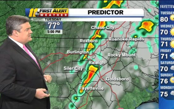
There’s a chance of severe weather in the Triangle and central North Carolina on Tuesday as a line of storms moves in from the west.
We’ll see scattered showers and storms, some of which could be severe. You’ll want to take your umbrella with you as you head out the door.
Most counties in the ABC11 viewing area are in the ‘slight’ risk area for severe weather, which is a level 2 out of 5. Some of the state sits in the ‘marginal’ (level 1) risk area.
Biggest threat this afternoon from damaging straight-line winds. We could see an isolated tornado spinup, but we will not see a widespread tornado outbreak. Though some localized flooding or an isolated pocket of hail may happen, not big threats today. #ncwx pic.twitter.com/JEJi3S7fKx
— Don Schwenneker (@BigweatherABC11) October 22, 2019
A large portion of our viewing area now under a Category 2 of 5 (slight) risk for severe weather tomorrow (Tuesday). Biggest threat=damaging wind, though we can’t rule out an isolated tornado or pocket of hail. We’ll be watching… #ncwx pic.twitter.com/2uUzPBDA00
— Don Schwenneker (@BigweatherABC11) October 21, 2019
Strong winds are the primary concern and an isolated tornado can’t be ruled out, especially in the sandhills where the warmest temperatures. Temps will top out in the low to mid-70s for much of the area. Some localized flooding or a small pocket of hail is possible as well.
Timing-wise, we’ll isolated showers Tuesday morning with scattered rain developing through the middle of the day. Pop-up storms will develop in the afternoon with the main window for storms coming between 2 p.m. and 5 p.m.
Stay with ABC11 on-air and online for the latest developments.
Copyright © 2019 WTVD-TV. All Rights Reserved.