- U.S. Supreme Court says Texans can sue state for flood damage
- This is how many hurricanes NC State researchers predict this year
- NC State researchers predict above-average hurricane season
- Supreme Court rules in favor of property owners suing Texas over flood damage
- Texas Land Commissioner announces extension for Houston to distribute federal relief funds for Hurricane Harvey
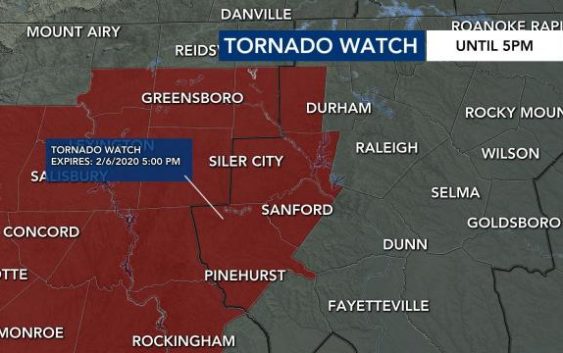
Granville, Person Schools closing early; tornado watch issued for counties west of Raleigh, including Chatham
Raleigh, N.C. — Severe weather will move into central North Carolina Thursday afternoon, bringing with it the potential for isolated flooding and tornadoes.
What to know
- Parts of Raleigh and counties south and west of Wake are under a level 3, or moderate, threat for severe weather Thursday.
- Storms could move into the Triangle by 4 p.m. and linger through 8 p.m.
- A tornado watch is in effect for several counties west of Raleigh, including Chatham, Orange, Lee and Moore, until 5 p.m.
- Several schools have canceled after-school activities, while Person, Granville, and others will close early. View all weather-related closings.
Updates
10:44 a.m.: Johnston and Sampson County Schools have both canceled all after-school activities for Thursday due to a threat for severe weather. Granville County Schools will release two hours early. All school closings.
The Storm Prediction Center upgraded parts of the Triangle to a level 3 risk for severe weather Thursday, including parts of Wake County.
Steady rain caused slow downs during morning commute, which had several accidents and closed roads.

The timeline of the severe weather’s arrival has moved up once again, likely to arrive even earlier than predicted by yesterday’s models.

The Triangle will see waves of rain through lunchtime, which will be heavy at times. WRAL meteorologist Elizabeth Gardner said, “By 4:45 the line of storms could already be in the Triangle–easily starting around 4, maybe 5 p.m.”
Then, she said, the line of severe storms seems to stall over the Triangle, still lingering through 8 p.m.
“Damaging wind gusts are our main threat,” said Gardner. “Gusts could knock down trees and cause power outages.”
The heavy rain brings potential for flooding, and isolated tornadoes are possible.
Back west, the approaching storm has caused 24 reports of tornado damage. The system brought thunder, lightning and tornado watches as it passed through Alabama and Georgia.
“The Triangle will likely go under a tornado watch or a severe thunderstorm watch later today, possibly by lunch time,” said Gardner.

“This is going to be a really serious situation for us,” said Gardner.
Between 2 to 3 inches of rain, wind gusts between 50 to 60 mph and isolated tornadoes will be possible with this system.
By 10 p.m., the threat should be in North Carolina’s eastern counties. By midnight, the threat should be mainly over. There could still be a chance of a shower in the morning.
To the west of the Triangle, heaver rain is expected with flash flooding possible. A flood watch has been issued for many counties in the WRAL viewing area from 6 a.m. Thursday to 1 a.m. Friday. Once the system goes through that part of the state, it is expected to begin to lose some of its punch as it moves east and off our coast by Friday morning.
Download the WRAL Weather App for mobile weather alerts.
After the rain moves out Friday morning, we’ll be left with cooler days. Highs in the low to mid 50s are expected for Friday and Saturday, but the weekend will be dry.

Heavy rains soaked large parts of Mississippi and Alabama early Tuesday, and two dozen counties in north Georgia will be under a flood watch through Friday morning, where some rainfall amounts could eclipse 5 inches, according to the National Weather Service.
Once the severe weather ends, the weekend will be cooler with temperatures near freezing Friday night and around 50 on Saturday afternoon. By Monday, temperatures will be in the upper 60s with Tuesday’s high expected to be near 70 with a 50 percent chance of rain .
