- List of hurricane names 2024
- Homeowners insurance doesn't cover floods: How to protect your home in North Carolina
- Before and after: See Dubai flooding from space
- No evidence of a tornado in Rock Hill, investigation determines
- Marking 15 years since 19,000 acre wildfire destroyed dozens of homes in Horry County
Powerful storms cause tornadoes, leave trail of destruction across Charlotte area
CHARLOTTE, N.C. — Multiple tornado warnings were issued across the Charlotte area as a powerful line of thunderstorms moves across the region the Carolinas Thursday morning, including multiple confirmed tornadoes along I-85.
Tornado Warnings were issued in nearly every county along I-85, including Mecklenburg throughout lunchtime. A neighborhood in Kannapolis suffered pretty heavy damage from a confirmed tornado on Lane Street at I-85. Emergency Management crews said a tornado was spotted on the ground in that area Thursday morning.
The entire Charlotte area remains under a Tornado Watch until 5 p.m. A severe thunderstorm warning is also in effect for Mecklenburg County and surrounding areas. Chief Meteorologist Brad Panovich said that warning has a “tornado tag,” meaning a tornado could form at any time within that line of storms.
Catawba County declared a State of Emergency due to the conditions. The National Weather Service is sending crews out to check for damage in several areas to confirm tornado damage.
Charlotte Douglas International Airport urged passengers to seek shelter in their bathrooms and the FAA evacuated its control tower. A WCNC Charlotte viewer said towers in uptown were being evacuated to stairwells.
LIVE BLOG: Multiple tornado warnings issued in Charlotte area
“It’s about the worst possible track the storm could have,” said Panovich.
Multiple school districts announced they would close early due to severe weather. Charlotte-Mecklenburg Schools said they will not dismiss early Thursday, but all afterschool activities have been canceled for the day.
Panovich says anyone in the storm’s path should be hypersensitive to the conditions.
“Anywhere along this line, I’m going to tell you to treat this line like it’s under one giant severe thunderstorm or tornado warning,” Panovich said. “Every single county along that line is under a Flash Flood Warning. Even if you’re not in the current warning areas, you’re going to be in some type of threat later.”
Some areas in the foothills reported wind gusts up to 58 mph, with some roads underwater in Burke and Catawba Counties. The mountains have seen a tremendous amount of rain with yet another line of storms expected Thursday afternoon. Flooding and downed trees will be the biggest concerns for most of the Charlotte area as the storms move through the region.
“Even if it the rain lets up for a second, don’t let your guard down,” Panovich said. “This is not the end of the event, it is really going to be picking up as we go into the afternoon.”
Some areas in the mountains have already seen up to 4 inches of rain from the first wave of storms. Creeks were seen overflowing their banks in Burke County. Mulcahy reported rain rates over more than 2 inches per hour with the storms.
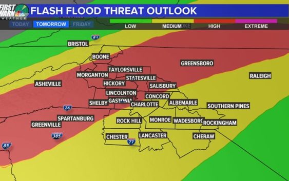
The entire Charlotte area is under a Flash Flood Watch until early Friday. Panovich said this system has created flash flooding everywhere it’s been so far and expects some Flood Warnings Thursday. Several school districts announced they will be dismissing early due to the forecast.
“I don’t want to discount that threat, but flooding is by far our biggest issue. You’re 10 times more likely to see flooding than any other severe weather,” Panovich said.
“They’re small, but for this time of year, it’s elevated, I’m not going to lie,” Panovich said. “For February, that’s a pretty significant tornado threat, especially areas south of Charlotte, like Columbia, South Carolina.”
Panovich said more than widespread tornadoes, it looks like a possibility for a couple of spin-ups.

WCNC
“Just wave after wave of heavy rain,” Panovich said. “There will be a lull at some point. It will be cloudy, but the clouds will be thin and we’ll be getting warm, humid air from the south. A backdoor cold front will be pushing in, and these winds are probably going to be rotating in the higher elevations, so the storms could produce higher winds.”
The second wave of storms Thursday afternoon will bring the biggest risk of severe weather. Panovich says the worst will likely be from around 3 p.m. through about 7.
There will be heavy rain and thunderstorms across the Carolinas until the early hours Friday morning.
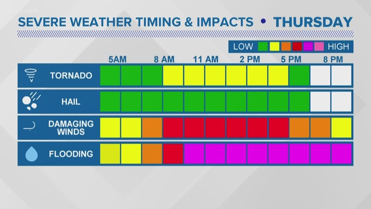
“There will be a ton of rain. That’s a given,” Panovich said. “The only question is how widespread the severe weather is. Really strong winds are mixing down to the surface, and are we going to have rotating storms? We don’t have a real good handle on where the rotation might occur just yet.”
Once the storms clear, Panovich expects a pretty big snow event for the mountains. By Friday, skiers will have plenty of options to hit the slopes in the high country.
The bottom line?
“There’s a 100% chance we’re going to see some flooding somewhere,” Panovich said. “There will be heavy rain for everybody, the question is how widespread the damaging winds and severe weather are.”
SEVERE WEATHER TIPS FROM BRAD PANOVICH