- List of hurricane names 2024
- Homeowners insurance doesn't cover floods: How to protect your home in North Carolina
- Before and after: See Dubai flooding from space
- No evidence of a tornado in Rock Hill, investigation determines
- Marking 15 years since 19,000 acre wildfire destroyed dozens of homes in Horry County
Triangle under level 2 severe weather threat this afternoon
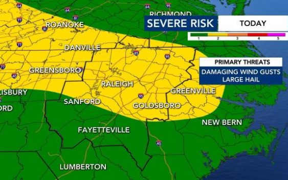
After two days of being at a level 1 risk for severe weather, Wednesday afternoon has been upgraded to a level 2 threat.
WRAL meteorologist Elizabeth Gardner said unusually warm temperatures will fuel another line of severe weather and thunderstorms Wednesday afternoon.
Highs in Raleigh on Wednesday afternoon will be in the upper 80s, about 15 degrees warmer than they were yesterday. Raleigh Temperature Tracker
Like Monday and Tuesday, the storms will be scattered and fast-moving, moving into the area in the afternoon.
“Like yesterday there will be plenty of instability and energy to fuel some strong to severe storms this afternoon and into the early evening hours,” Gardner said.
Subscribe to get WRAL severe weather alerts on your device.
Strong wind gusts and the potential for hail will be the biggest threats.
Wednesday afternoon will feel like summer and, with a high around 87 degrees, could come close to tying or breaking the old record highs for the day.
Thursday will stay very warm, with a high in the low 80s and another chance for afternoon storms. With dry air, warm temperatures and wind gusts between 35 and 40 mph, there will be an elevated fire risk.
Temperatures won’t get mild again until Friday and the weekend — all three days will see highs in the low to mid 60s. Storms will be less likely.
