- Habitat for Humanity helping Rock Hill residents assess, clean up storm damage. They are also seeking volunteers
- Smokehouse Creek wildfire victims line up lawsuits against utility
- Will Mexico wildfires impact Houston's air quality?
- The worst tornadoes in North Carolina History
- Hurricane-proof your NC home: Essential steps to weather the storm
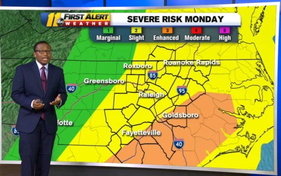
Pleasant Easter Sunday, enhanced risk of severe weather Monday morning
Easter Sunday will feature some showers for central North Carolina but the storms will arrive well after midnight and will likely fire up during Monday morning.
The Storm Prediction Center has issued a level 2 out of 5 slight risk of severe weather for our region for both Sunday and Monday. However, parts of the Sandhills, such as Fayetteville, is in a level 3 out of 5 area of enhanced risk for severe weather on Monday.
Here’s a play-by-play time frame of what to expect for central North Carolina throughout Sunday and into Monday:
Sunday Morning
Easter Sunday begins calm and quiet with loads of sunshine to begin the day. Temperatures will start in the upper 40s/low 50s. Make sure to grab a jacket if you plan on stepping outside to walk the dogs.
Sunday Afternoon
If you have a social distancing Easter egg hunt planned, this will be the time to do it! We’ll see an increase in clouds as we go throughout the day but it’ll be a nice afternoon with temperatures reaching into the low to mid-70s. It’ll be breezy due to a 10-15 mph southeasterly wind.
Sunday Night
By Sunday evening, skies will begin to look more ominous. Our first chance of showers begins Sunday evening, likely after 6 p.m. western North Carolina will receive the showers first, however, those will advance into central North Carolina and look to be more prominent around 10:30 p.m.
RELATED: Duke Energy prepares for outages ahead of Easter weekend storms
Overnight Sunday into Early Monday
This is when the likelihood and coverage of showers increase. Not only will there be showers across the region, but there will also be the threat of storms. Storms may be so strong that they wake you up overnight and howling winds will be present as well.
Monday Morning
The bulk of the action arrives after Monday’s sunrise. Storms will be across the region throughout the morning. The main threat will be damaging winds and we may see winds gust up to 50 miles per hour at times. Flash flooding, large hail and an isolated tornado is possible during this time frame as well – but again – the main threat is going to be damaging wind gusts.
Monday Afternoon
By Afternoon there may be a lingering shower in a few sports across central North Carolina, but this is when most of us begin to dry out. It’ll still be a breezy day but will begin to slacken after the showers and storms come to an end.
Copyright © 2020 WTVD-TV. All Rights Reserved.