- Couple accused of creating videos of young girls using hidden cameras at The Woodlands Mall, Hurricane Harbor
- Couple accused of creating videos with hidden cameras at The Woodlands Mall, Hurricane Harbor
- The Texanist: Texas Gets More Tornadoes Than Any Other State, but Don’t Freak Out
- U.S. Supreme Court says Texans can sue state for flood damage
- This is how many hurricanes NC State researchers predict this year
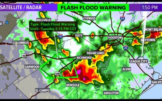
Flash flood warning issued for parts of southeast Texas
You may want to leave the alerts on your phone enabled as you sleep so you can be aware of any severe weather moving in.
HOUSTON — Just before noon, we had one storm get strong enough to merit a severe thunderstorm warning put on it. It was producing heavy rains, small hail and gusty winds. It expired across Fort Bend, Wharton & Brazoria counties but the flooding potential is still there, as 3-4 inches of rain have already fallen. Be on the look out for flash flooding in that area as well (southwest of the Loop).
Some areas are getting some storms and showers this afternoon and there’s even a chance for even stronger storms, and possibly severe weather, on the way overnight, especially on the northside and into the DFW area.
There is a flash flood warning in effect for southwestern Fort Bend and northeastern Wharton counties until 2:15 p.m.
GET ALERTS ON YOUR PHONE: Download the KHOU 11 app
TRACK THE WEATHER: Houston weather radar
STORM TIMELINE
TUESDAY 5 p.m. — Stormy weather will decrease, but we could still have isolated showers and thunderstorms
TUESDAY 10 p.m. — Chance for rain increases again late tonight into very early Wednesday morning
WEDNESDAY 2 a.m. — Now is the time to start watching the radar for any severe activity moving in from the north – our northern communities (like Montgomery County and Walker County) will get the bad weather first, starting around midnight
Take a look at that Futuretrack radar for Wednesday morning. See how the storm line segments (red) are bent… or ‘bowing’ out? That’s what we call a ‘bow-echo’ and it indicates the threat for damaging straight line winds.
WEDNESDAY 4 a.m. — 80% chance for rain across our area as the severe weather threat continues and moves into the City of Houston; the chance for severe weather is mostly on the north side and north of Houston
WEDNESDAY 6 a.m. — The worst of the weather should moving toward the coast and out of our area, although many of our coastal communities only have a slight risk of severe weather
WEDNESDAY 10 a.m. — Scattered showers and a few storms continue through the morning
WEDNESDAY 12 p.m. — By lunchtime and the afternoon the rain chance drops dramatically, leaving only partly cloudy skies
WHAT TO EXPECT
The Storm Prediction Center has the much of the Houston metro area in a ‘slight risk’ (2 out of 5). Areas just to our north (from northern Harris county northward) is at a threat level 3. The KHOU weather team will be tracking the potential for strong, straight line damaging winds ahead of a cold front that will be pushing through overnight.
We ask that you stay weather aware and since this is an overnight event and we recommend that you have multiple ways of receiving weather alerts. The KHOU app is one of those ways that we highly recommend. Here’s what you need to know:
HOUSTON 7-DAY FORECAST
Once we get past Wednesday morning, rain chances will decrease and things will start to heat up! Full sunshine and big temperatures will greet us heading into the end of the week and weekend. We’ll make our way into May, on Friday, with highs into the 90s. The record daytime highs for the weekend are; Friday – 94 in 1947, Saturday – 96 in 1964, and Sunday – 93 in 1890. While we won’t be look to race past these records, we’ll certainly be in their ballpark range.