- Couple accused of creating videos of young girls using hidden cameras at The Woodlands Mall, Hurricane Harbor
- Couple accused of creating videos with hidden cameras at The Woodlands Mall, Hurricane Harbor
- The Texanist: Texas Gets More Tornadoes Than Any Other State, but Don’t Freak Out
- U.S. Supreme Court says Texans can sue state for flood damage
- This is how many hurricanes NC State researchers predict this year
Slow-moving line of thunderstorms could bring localized flooding Thursday morning
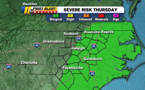
RALEIGH (WTVD) — A storm system moving across the Great Lakes region Wednesday will continue to glide to the east.
The cold front hanging south off of it will reach the spine of the Appalachians tonight, then advance west to east across North Carolina. This front will bring rain later tonight into tomorrow morning.
The leading edge of the rain could include some strong or severe thunderstorms. These would contain damaging wind gusts, a heavy downpour and perhaps hail.
Here’s the latest from the SPC:
Severe risk from @NWSSPC will cross our area tonight into tomorrow. Biggest threat from damaging wind. Timing is early tomorrow morning. These could be slow movers putting down 2+” of rain & causing localized flooding. #ncwx pic.twitter.com/lIc111w37r
— 𝘿𝙤𝙣 𝙎𝙘𝙝𝙬𝙚𝙣𝙣𝙚𝙠𝙚𝙧 (@BigweatherABC11) April 29, 2020
Some good news, since the front will be arriving close to daybreak tomorrow, it will occur during a time of day that is not favorable for severe weather at this time of year. Nonetheless, do not let your guard down as some potent upper-level dynamics associated with this system could make up for the lack of strong instability at the surface.
Total rain from this system should average between 0.75 and 1.50 inches. But in some of the heavier storms, there may be up to 2 inches. This would be enough to cause localized flash flooding in spots, especially poor-drainage areas.
Copyright © 2020 WTVD-TV. All Rights Reserved.