- Couple accused of creating videos of young girls using hidden cameras at The Woodlands Mall, Hurricane Harbor
- Couple accused of creating videos with hidden cameras at The Woodlands Mall, Hurricane Harbor
- The Texanist: Texas Gets More Tornadoes Than Any Other State, but Don’t Freak Out
- U.S. Supreme Court says Texans can sue state for flood damage
- This is how many hurricanes NC State researchers predict this year
LIVE: Tornado Warning issued for Lee County, Flash Flood Warning issued for Travis, Hays counties
AUSTIN, Texas — Send your weather video to our newsroom at kvuedigital@kvue.com or send it to our Facebook or Twitter inboxes.
Check back on this blog for live updates:
12:12 p.m. – Spotters continue to report funnel clouds associated with this circulation headed towards Dime Box along Highway 21, according to the National Weather Service.
11:58 a.m. – The National Weather Service issued a Tornado Warning in Lee County, including the Lincoln and Dime Box until 12:30 p.m.
11:53 a.m. – A Flash Flood Warning has been issued for Hays and Travis counties until 3 p.m.
11:47 a.m. – TxDOT issued a traffic advisory for the Austin area as heavy rain created puddles along some roads.
11:45 a.m. – A severe thunderstorm warning near Lexington in Lee County was issued until 12:15 p.m.
According to the National Weather Service, the circulation has moved out of Bastrop County, ending the tornado threat for Bastrop County as all of the strong storms are now to the N & E of the county. But the circulation remains strong west of Giddings.
11:30 a.m. – The tornado warning issued for Bastrop and Lee counties, where rotation was indicated along Highway 290 near Paige, has been extended to noon. Hail in this storm near Paige is producing quarter to dollar size.
11:11 a.m. – A flood advisory was issued for Travis, Hays and Comal counties until 2:15 p.m.
11:02 a.m. – A tornado has been confirmed northwest of Smithville by the National Weather Service. KVUE viewer Valarie Harmon sent us this video of a tornado moving through Upton, which is near Smithville. Cadie Marrs sent KVUE some video, as well.
10:54 a.m. – The tornado warning for Bastrop and Lee counties was extended to 11:30 a.m.
10:49 a.m. – A tornado warning for Bastrop and Lee counties was issued until 11 a.m. Bastrop County has two warnings: one west of Smithville and one north of Smithville. The storm is moving in a northeast direction at 20 mph.
10:45 a.m. – One of the three tornado warnings in Bastrop County, which was near Cedar Creek, has expired.
10:37 a.m. – A third tornado warning was issued in Bastrop County just southwest of Smithville. The warning was issued until 11 a.m.
10:34 a.m. – The tornado warning in Fayette County has been expired.
10:20 a.m. – Two tornado warnings were issued for Bastrop county until 10:45 a.m. Tornado warnings were also issued in Lee and Fayette counties.
Meanwhile, heavy rain extends into Hays and portions of Travis County .
10:15 a.m. – A severe thunderstorm warning was issued for Bastrop and Caldwell counties until 11 a.m. We are watching rotation in this storm, heavy rain, strong winds. Storm is moving northeast at 15 mph.
10:00 a.m. – The National Weather Service has issued a Severe Thunderstorm Warning for Bastrop County.
10:00 a.m. – The National Weather Service expired the tornado warnings.
9:45 a.m. – The National Weather Service extended the tornado warning for Bastrop County until 10 a.m.
9:15 a.m. – A tornado warning has been issued for Bastrop and Caldwell counties until 9:45 a.m. At 9:15 a.m., a severe thunderstorm capable of producing a tornado was located 10 miles east of Lockhart, moving northeast at 20 mph, according to the National Weather Service.
KVUE’s Mariel Ruiz gave an update on the tornado warning here:
A shift in the tide has begun Central Texas. The lovely weather that wooed our family and friends to venture outdoors and soak up the rays will be a bit harder to find in the days to come.
Moisture and humidity levels have climbed thanks to breezy southeasterly winds off the Gulf of Mexico. As a result, more cloud cover is seen Tuesday.
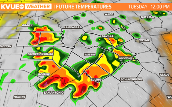
We are tracking two clusters of storms that will bring rain into the area. Our southern counties will see rain due to storms building in from the south. Our western counties will see rain due to remnant storms from Monday’s West Texas storms. Rain moves in mid-morning and will move, overall, from west to east through the afternoon.

KVUE
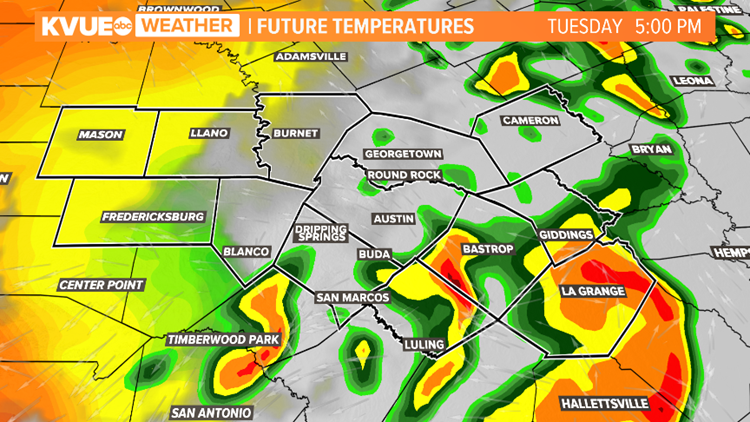
A few storms could be on the strong side with heavy rain, gusty winds, and small hail as the main threats. Rain moves out of the area by 9 pm Tuesday. Rainfall totals for the area on Tuesday will be between one to two inches.
KVUE
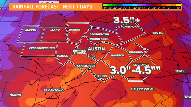
A mostly dry pattern continues for Wednesday and Thursday.
Better chances for rain will come Friday evening and the weekend. Weekend rain will be heavy at times. Rain totals in the next seven days are expected to be between 3 to 3.5 inches with some localized areas of over four inches. This increases our flood threat.
KVUE
Stay tuned as we fine tune the weekend forecast!
The KVUE Storm Team will continue to monitor this developing forecast.
The extended forecast can be found below: