- Couple accused of creating videos of young girls using hidden cameras at The Woodlands Mall, Hurricane Harbor
- Couple accused of creating videos with hidden cameras at The Woodlands Mall, Hurricane Harbor
- The Texanist: Texas Gets More Tornadoes Than Any Other State, but Don’t Freak Out
- U.S. Supreme Court says Texans can sue state for flood damage
- This is how many hurricanes NC State researchers predict this year
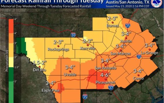
Heavy rainfall with potential for flooding in SA through Tuesday
-
San Antonio can expect to see heavy rainfall with the potential for localized flooding through Tuesday.
San Antonio can expect to see heavy rainfall with the potential for localized flooding through Tuesday.
Photo: Courtesy NWS
San Antonio can expect to see heavy rainfall with the potential for localized flooding through Tuesday.
San Antonio can expect to see heavy rainfall with the potential for localized flooding through Tuesday.
Photo: Courtesy NWS
San Antonio can expect to see heavy rainfall with the potential for localized flooding through Tuesday.
Saturday evening there will be thunderstorm development to the west of our area near the border. However, overnight those storms could move farther east and reach our area with the potential to bring lighting and a slight risk of small hail.
Sunday moisture levels increase and San Antonio will have another chance for rain and thunderstorms. These storms could bring another round for San Antonio to experience gusty winds and hail. Greater chances for storm activity will be in the evening with the potential for locally heavy rainfall and flooding. Rainfall amounts could range from 1-2 inches and higher amounts possible in localized areas.
Memorial Day the shower and storm activity will remain in the forecast with heavy rainfall possible in the evening through Tuesday night. Rainfall amounts by Tuesday afternoon could range from 3-4 inches. Flooding is again possible in localized areas.
Teresa Velasco is a digital producer for mySA and the San Antonio Express-News. She has a bachelor’s degree in broadcast meteorology. She uses data provided by the National Center for Atmospheric Research, the National Oceanic and Atmospheric Administration and others for her forecasts.