Live blog: Flood Advisory issued for Hays County
Isolated to strong rain storms are possible in the days to come.
AUSTIN, Texas — After an active Sunday evening and night, things have begun to calm down in the Central Texas region. However, another round of strong to severe thunderstorms are indeed expected in the hours and days ahead.
Memorial Day Monday has a moderate to slight risk for severe storms with the greatest threats being moderate to heavy rain. In some areas, excessive rainfall and hail along are possible with gusty winds. A slow-moving system will traverse south and east across the tri-county area and that poses a significant threat to those areas that have accumulated their fair share of rainfall the past few days.
Here are today’s live updates:
1:40 p.m.: A Flood Advisory has been issued for Hays County until 3:45 p.m. One to two inches of rain have already fallen as storms continue in the area.
MORE:
With plenty of moisture available, dew point temperatures are expected to climb again into the upper 60s and 70s so mugginess will be along as well today.
Some of Monday afternoon’s storms could create quite a rumble with plenty of instability, heat and humidity available. So, the window of opportunity to enjoy outdoor barbecuing and venture to some local parks need to be at the risk of what radar shows as some storms could grow into supercellular with gusty winds, large hail and an isolated tornado possible.
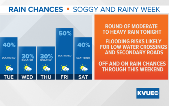
Given the heavy rain in some areas this past weekend, models continue to show signs of an additional one to three inches as tonight’s cold front passes.
At this time, the main event looks to occur after midnight and should exit by sunrise Tuesday. Some wrap-around showers will be possible through the daytime with cooler-than-normal high temperatures: upper 70s for the Hill Country and low 80s for the Austin metro area.
In the days to come, the upper-level low drifts northeast and some stray showers and storms could filter back into Central Texas through the rest of the week. Whether or not these provide enough concern for severe threats or flooding continues to keep our attention; however, it is important to remember “Turn Around, Don’t Drow,n” as familiar passages can become unfamiliar quickly with heavy rain and poor visibility.
PEOPLE ARE ALSO READING: