- Habitat for Humanity helping Rock Hill residents assess, clean up storm damage. They are also seeking volunteers
- Smokehouse Creek wildfire victims line up lawsuits against utility
- Will Mexico wildfires impact Houston's air quality?
- The worst tornadoes in North Carolina History
- Hurricane-proof your NC home: Essential steps to weather the storm
June 1 begins the 2020 Atlantic hurricane season
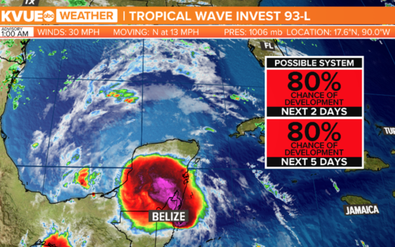
As the 2020 season officially opens, a new storm churns over the Yucatan peninsula.
AUSTIN, Texas — The month of June normally brings a quieter yet modestly active time in the weather department to Central Texas. As we begin the month, a few isolated showers and storms can be expected as we monitor the track of a low-pressure disturbance near the Texas-Mexico border.
Additionally, June 1 is the official beginning of the Atlantic hurricane season. So far in 2020, we’ve had our first two named storms: Arthur and Bertha. Our next named storm to come would be Cristobal.
As of 7 a.m. Monday morning, the information from the National Hurricane Center shows a large area of unsettled weather which are remnants of an earlier Pacific tropical storm, Amanda. The disturbance is over the Yucatan Peninsula and depending on Monday’s environmental conditions, has an 80% likelihood of developing into a tropical storm within the next two to five days.
The forecast is for the storm to continue drifting northwestward and eventually west-southwest by midweek. It is too soon to forecast whether the track eventually brings it near the Lone Star state; however, continuous tracking and monitoring will continue as the week wears on.
Here’s a look at this week’s rain chances.
The Climate Prediction Outlooks eight to 14-day look continues to keep rainfall chances at a minimum leading towards a drier and warmer for two weeks.
PEOPLE ARE ALSO READING: