- Couple accused of creating videos of young girls using hidden cameras at The Woodlands Mall, Hurricane Harbor
- Couple accused of creating videos with hidden cameras at The Woodlands Mall, Hurricane Harbor
- The Texanist: Texas Gets More Tornadoes Than Any Other State, but Don’t Freak Out
- U.S. Supreme Court says Texans can sue state for flood damage
- This is how many hurricanes NC State researchers predict this year
Tropical Storm Cristobal Progressing Toward US Gulf Coast
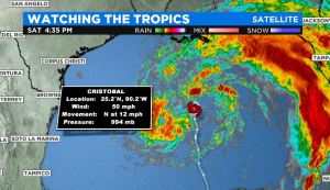
(CBSDFW.COM) – Cristobal remains a moderately strong tropical storm with max sustained winds at 50 mph Saturday afternoon.
The storm is moving north at 12 mph through the central Gulf of Mexico and is expected to make landfall along the Louisiana coast late Sunday, and then progress northward across Arkansas and Missouri Monday into Tuesday, weakening as it moves over land.
The impacts to North Texas are expected to be minimal. Some of our eastern counties may see a few light showers and isolated storms Monday, but if you live along and west of I-35 you may not notice anything.
The forecast calls for partly cloudy to mostly sunny skies for most in North Texas on Monday with highs in the low to mid 90s. It’s mainly our eastern counties that may see a few more clouds and those scattered light showers.
It will be an entirely different story for areas along the Gulf Coast from Louisiana into Mississippi, Alabama and even parts of the Florida panhandle.
Dangerous storm surge, four to eight inches of rainfall with isolated higher amounts and even isolated tornadoes caused by the outer bands of Cristobal will be issues for the next couple of days.