- Couple accused of creating videos of young girls using hidden cameras at The Woodlands Mall, Hurricane Harbor
- Couple accused of creating videos with hidden cameras at The Woodlands Mall, Hurricane Harbor
- The Texanist: Texas Gets More Tornadoes Than Any Other State, but Don’t Freak Out
- U.S. Supreme Court says Texans can sue state for flood damage
- This is how many hurricanes NC State researchers predict this year
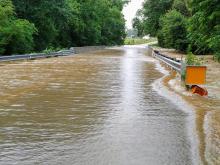
Rain backs off in Triangle, flash flooding hits northeastern counties
Rain chances will start to back off in the Triangle on Wednesday and Thursday while other areas could see downpours and isolated flooding.
Rain showers, which could be heavy at times, are likely across central North Carolina on Wednesday, but counties northeast of the Triangle are most at risk for flooding. Person, Granville, Franklin, Nash, Vance and Warren counties were under a flash flood warning until 12:15 p.m.
Those counties will see the most rain on Wednesday, but southern counties could see some sunshine as the slow-moving low pressure system lifts to the north.
Track rain with the DualDoppler5000.
Senior citizens in Spring Hope were rescued from their flooded car, and trees were down in Franklin County. A family had to be rescued from their Rocky Mount home.
By Wednesday night and Thursday, everyone should notice a decrease in rain, and the system should move away by Friday. There is, however, some rain in the forecast through Sunday.
After two days of temperatures in the 60s, Wednesday will be warmer, with a high around 73 degrees in Raleigh. Thursday and Friday will feature highs in the low to mid 80s, which is typical for mid-June.

According to WRAL meteorologist Peta Sheerwood, the intensity of the rain will decrease throughout the week, and we should see some sunshine by Thursday.

The weekend should be mostly clear but hot, with highs in the upper 80s or lower 90s. There is a lesser chance for thunderstorms each day.