- List of hurricane names 2024
- Homeowners insurance doesn't cover floods: How to protect your home in North Carolina
- Before and after: See Dubai flooding from space
- No evidence of a tornado in Rock Hill, investigation determines
- Marking 15 years since 19,000 acre wildfire destroyed dozens of homes in Horry County
Flash Flood Warning continues until 10 a.m. after early-morning street flooding | Watch live radar
The worst of this morning’s weather is now pushing to the southeast, giving the Katy area a break.
HOUSTON — A Flash Flood Warning continues for northeastern Jackson County, south central Austin County southeastern Colorado County, west central Fort Bend County and Wharton County until 10 a.m. Thursday.
The worst of this morning’s weather is now pushing to the southeast, giving Katy and the rest of Fort Bend County/western Harris County a break from the street flooding.
A Flash Flood Watch is also in effect for a portion of Southeast Texas, including the following areas: Austin, Colorado, Fort Bend, Harris, Waller and Wharton until 10 a.m. Thursday.
HIGH WATER LIST: High water spots in our area | Live freeway cameras
At this time there are no confirmed reports of flooding in structures. The main concern with this morning’s storms and downpours is isolated street flooding, especially in problematic spots.
It looks like we will receive two rounds of rain today. One in the very early morning and then another in the warmth of the afternoon. The major concern will be ponding and water in the roadway. Stay weather aware and check the radar if you must get on the roads.
Forecast update with Meteorologist Chita Craft
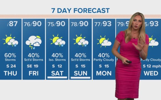
Houston 7-day forecast
Rain chances will diminish but not completely go away this weekend as dust from the Saharan Desert arrives. As the dust moves in, skies may become a bit hazy.
The good news with the dust, which is over the Atlantic Ocean and moving into the Caribbean Sea soon, has helped keep the tropics calm, so no hurricanes and tropical storms anywhere in sight, likely for the rest of this month. Tropical Storm Dolly, is the exception, since it formed in the Northern Atlantic Ocean but will pose no threat to land.