- The Texanist: Texas Gets More Tornadoes Than Any Other State, but Don’t Freak Out
- U.S. Supreme Court says Texans can sue state for flood damage
- This is how many hurricanes NC State researchers predict this year
- NC State researchers predict above-average hurricane season
- Supreme Court rules in favor of property owners suing Texas over flood damage
National Hurricane Center increases chance that tropical storm forms off NC coast Thursday
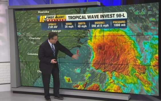
RALEIGH (WTVD) — The National Hurricane Center is monitoring two areas of low pressure near the United State’s coast; one has already formed into a tropical system and the other is expected to do so Thursday.
Fay?
The system that has yet to turn tropical is located right off the North Carolina coast.
The National Weather Center said it has an 80 percent chance to become a tropical depression or storm soon. If it does strengthen and organize, it will be named Fay.
Even if it becomes a named storm, our impacts in central North Carolina won’t change. We’ll continue to see scattered storms and cooler temperatures through Thursday. The area of low pressure will continue moving northeast, away from the North Carolina coast through the weekend.
RELATED:New 2020 hurricane prediction warns of more named storms
Drier air pushes in Friday lowering rain chances, and heating things up. Highs will reach the low 90.
Cristina
Tropical Storm Cristina formed late Monday night local time in the Eastern Pacific Ocean and is on its way to becoming the first hurricane of the 2020 season in any of the Western Hemisphere ocean basins.
As of Wednesday morning, the storm was located several hundred miles south of the southern tip of the Baja California peninsula. It was moving away from the mainland at a speed of 12 mph and featured maximum sustained winds of 65 mph.
Thus far there have been three tropical storms and one tropical depression in the Eastern Pacific basin this year.
Meanwhile the Atlantic has had five tropical storms, and could be on the verge of a sixth-named storm this week.
Neither basin has yet spawned a hurricane, but that is about to change.
AccuWeather meteorologists expect Cristina to become not only the first hurricane of the North and Central American waters, but perhaps the first Category 2 hurricane with maximum sustained winds of at least 96 mph.
Copyright © 2020 WTVD-TV. All Rights Reserved.