- The Texanist: Texas Gets More Tornadoes Than Any Other State, but Don’t Freak Out
- U.S. Supreme Court says Texans can sue state for flood damage
- This is how many hurricanes NC State researchers predict this year
- NC State researchers predict above-average hurricane season
- Supreme Court rules in favor of property owners suing Texas over flood damage
Tropical Storm Gonzalo develops, shattering yet another Atlantic record
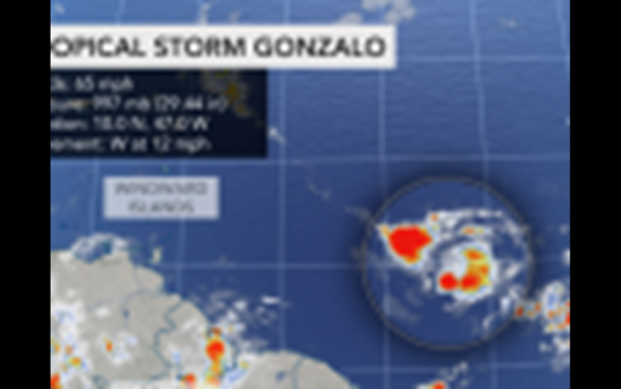
Tropical Storm Gonzalo developed in the central Atlantic, about 1,250 miles east of the southern Windward Islands, on Wednesday morning, setting yet another record for the basin. Gonzalo is the earliest ever “G” named storm since the satellite era of the 1960s, beating out Tropical Storm Gert, which formed on July 24 amid the intense 2005 hurricane season.
After forming into Tropical Depression 7 around 5 p.m. on Tuesday, the system strengthened enough to be given the name Gonzalo shortly before 9 a.m. Wednesday when maximum sustained winds increased to 45 mph, according to the National Hurricane Center (NHC).
As of 5 a.m. EDT Thursday, winds were sustained at 65 mph as the storm moved along to the west at 12 mph. Gonzalo is likely to become a hurricane prior to reaching the Windward Islands, and a hurricane watch is in effect for Barbados.
Many storms this year have beat out storms from the notorious 2005 season, known as the most active on record, for the title of earliest to form in the basin, but the 2020 season pales in comparison in terms of overall intensity. By this point in 2005, the Atlantic basin had already spawned three hurricanes and two major hurricanes – Category 3 or higher – according to Philip Klotzbach, a tropical meteorologist at Colorado State University.
The formation of Tropical Depression 7, now Tropical Storm Gonzalo, ended what was a lull in tropical activity across the basin that lasted about 10 days after Tropical Storm Fay dissipated on July 11 after moving ashore over the interior northeastern United States.
Gonzalo strengthened in a pocket of relatively low wind shear, or changing wind with altitude, and a moist atmosphere — both factors that favor strengthening into a tropical system.
Waters are sufficiently warm — in the low to mid-80s — to support further development of this system over the next couple of days, prior to it approaching the Windward Islands.
“We expect Gonzalo to ramp up to a Category 1 hurricane prior to reaching the Windward Islands,” AccuWeather Senior Meteorologist Rob Miller stated.
However, as the system approaches the island, conditions may become more hostile for development and could lead to weakening after the strengthening phase.
“This system is likely to encounter increasing wind shear and then perhaps resistance from the large landmass of South America late this week since it is a bit far south compared to other tropical systems that have developed over the years,” AccuWeather Senior Meteorologist Adam Douty said.
Whether or not the system survives the encounter with South America and an uptick in wind shear may depend on how strong or organized it becomes prior to its arrival.
If the feature remains weak, then it is more likely to break up as it nears and moves into the Caribbean. But, if the feature ramps up quickly, then it may have a better chance of surviving and lasting for many days upon moving westward through the Caribbean.
“The storm’s rather small size may actually help the system dodge some of the effects from South America, provided it does not ram into the continent and stays south of a zone of dry air and dust farther to the north,” Miller explained.
The system is the first true Cabo Verde tropical cyclone of the season.
Cabo Verde is a group of islands just off the coast of Africa. The Cabo Verde season makes up the backbone of the Atlantic hurricane season as tropical waves which move off the coast of Africa pass near these islands prior to moving westward over the ocean.
Prior systems this year have formed from non-tropical features closer to the U.S., in the western Atlantic and Gulf of Mexico. Cristobal originated from — in part — leftover moisture from an eastern Pacific system, Amanda, becoming a rare crossover storm.
Interests in the Windward Islands and along the northern coast of South America should monitor the progress of Gonzalo. If the system holds together, an uptick in showers and thunderstorms would occur in the Windwards beginning Friday night and will spread westward over the southeastern part of the Caribbean during the weekend.
“The AccuWeather RealImpact™ Hurricane Scale for Gonzalo on the Windward Islands is estimated to be a one since the storm may still be close to hurricane strength upon arrival,” Miller said.
Conditions over the islands may vary from needed rainfall to flash flooding and mudslides. A general 2-4 inches (50-100 millimeters) of rain is forecast with an AccuWeather Local StormMax™ of 6 inches (150 millimeters) anticipated.
Seas will build late in the week due to the storm’s approach with a minor to moderate storm surge anticipated.
While the exact conditions will depend on the track and strength of the small system, at this time islands from Grenada and Saint Vincent and the Grenadines may have the most substantial impact from Gonzalo. These aforementioned islands stand the best chance of strong tropical storm to hurricane-force wind gusts, which could trigger power outages.
Once the behavior of the system becomes established near the Windwards, a more definitive impact on the balance of the Caribbean can be determined. Steering breezes would likely take Gonzalo on a general west to northwest path later this weekend and early next week. As a result all interests in the Caribbean should monitor the progress of the storm.
Thousands of miles farther to the northwest, a disturbance which AccuWeather meteorologists have been keeping a close eye on for several days became Tropical Depression Eight on Wednesday evening.
This is the same system that recently soaked parts of Cuba and Florida. The feature, which is a Cabo Verde system like Gonzalo, could take a run at the record for the earliest eighth named storm on record in the Atlantic.
As of Thursday morning, July 23, 2020, the Atlantic hurricane season has spawned eight tropical depressions, seven of which organized further into tropical storms, many of which set new records for earliest formation ever in the basin.
On July 9, Fay unseated another entry in a long list of 2005 tropical storms that held early-season records. The prior earliest sixth-named storm in recorded history was Franklin which formed on July 21, 2005, near the central Bahamas and traveled northeastward, well to the east of the U.S. coast. The storm did not reach hurricane strength.
On July 5, Edouard became the earliest fifth-named tropical storm in any Atlantic hurricane season since the satellite era of the 1960s. Edouard beat out Emily, which formed on July 12 and went on to become a Category 5 hurricane in the Caribbean Sea in 2005, by a week.
Cristobal became the earliest “C” named storm in recorded history for the Atlantic on June 2, a feat that typically does not occur until around the middle of August. The storm went on to crash ashore along the Gulf coast, where it unleashed flooding rains. Dolly was the second-earliest “D” named storm ever in the basin, but it moved out to sea without impacting land.
Arthur and Bertha, as well as Dolly, formed in the same near-coast waters of the eastern U.S. this season. Both Arthur and Bertha formed in May, prior to the officials start of hurricane season on June 1.
The 2005 hurricane season holds the earliest dates for tropical storms that start with the letters “H” through “K,” when Katrina formed on Aug. 24. Harvey formed on Aug. 3, 2005. The name Harvey would eventually be retired after the 2017 season when a different Harvey brought devastating flooding to Texas. Now that Gonzalo has taken the record away from Gert by forming two days earlier, the “H” storm is now in contention for 2020.
Despite there being seven tropical storms already in 2020 over the Atlantic basin, there have not yet been any hurricanes. However, the average date for the first hurricane of the season is not until Aug.10.
AccuWeather is projecting the busy nature of the season to continue with up to 20 named tropical storms, seven to 11 hurricanes and four to six major hurricanes. Three U.S. landfalls are already in the books for 2020 — and the heart of the hurricane season does not occur until the middle of September.
Keep checking back on AccuWeather.com and stay tuned to the AccuWeather Network on DirecTV, Frontier and Verizon Fios.