- Couple accused of creating videos of young girls using hidden cameras at The Woodlands Mall, Hurricane Harbor
- Couple accused of creating videos with hidden cameras at The Woodlands Mall, Hurricane Harbor
- The Texanist: Texas Gets More Tornadoes Than Any Other State, but Don’t Freak Out
- U.S. Supreme Court says Texans can sue state for flood damage
- This is how many hurricanes NC State researchers predict this year
Hurricane Isaias approaching Florida late Saturday as Category 1 storm before turning north toward Carolinas
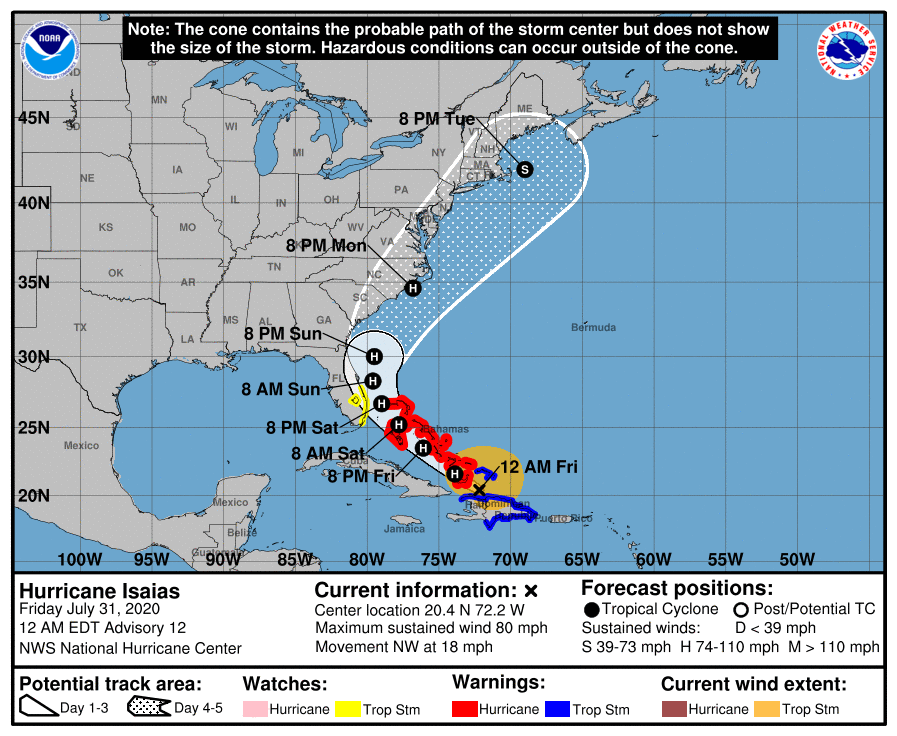
RALEIGH, N.C. (WTVD) — As of 5 a.m. Saturday, Isaias remains a Category 1 hurricane making its way through the Bahamas. The storm is traveling with maximum sustained winds of 85 mph with gusts up to 105 mph and is moving northwest at 12 mph.
Meteorologist Steve Stewart says there’s a lot of dry air on Florida’s coast, so Isaias will most likely hold its form and not strengthen.
Hurricane Isaias is expected to bring dangerous storm surge to the Bahamas through Saturday. Storm surge is possible along the east coast of Florida.
With it’s eventual turn to the north, Isaias is still expected to bring heavy rain and potential flash floods to low-lying areas across Florida and the Carolinas.
There are a lot of variables as to when and where Isaias will make a turn northeast to possibly impact the Carolinas.
Models still show Isaias affecting the North Carolina coast late Monday into Tuesday.
Friday, Gov. Roy Cooper issued a state of emergency for the state of North Carolina ahead of Hurricane Isaias.
FULL STORY HERE: Gov. Roy Cooper declares state of emergency for NC ahead of Hurricane Isaias
The most important question is how far west will the storm go before turning north.
Some models including the Canadian have it coming onshore in south Florida and making its way to the west coast of Florida before turning back to the northeast. The more trusted EURO and GFS make the turn north sooner, keeping Isaias right along the east coast of Florida.
When that turn happens is very difficult to predict and can make all the difference in the world in what effects the storm brings to North Carolina.
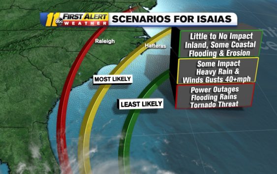
If the storm pushes up along the coast of Florida and drives more north than northeast, central North Carolina could be in for flooding rain, tornadoes, and widespread power outages. If the storm gets out of the Bermuda High (northwesterly winds around an area of high pressure) and gets pushed by an area of low pressure currently working its way across the central USA, the storm could turn out to sea.
All of those scenarios will be better understood in the next 36 hours (by Saturday night/Sunday morning). As soon as the system makes its turn north, the ABC11 First Alert Team will be able to make a much better assessment of the specific impacts Isaias will have in your neighborhood.
Storm Ready 2020: Preparing in a Pandemic
Meanwhile, a mandatory visitor evacuation is in order for both Ocean Isle Beach and Ocracoke Island. Both areas will be restricted to residents, homeowners, vendors, and other essential personnel.
On Friday morning, the storm was spinning around Turks & Caicos and dumping heavy rain on the Bahamas. The National Hurricane Center said flash-flooding and mudslides are possible across the Dominican Republic, northern Haiti, Turks & Caicos and the Bahamas.
On Thursday, more than 400,000 customers in Puerto Rico lost power, according to ABC News. Some were trapped in flooding.
The North Carolina coast is already seeing effects of Isaias as a high risk rip current goes into effect starting Friday stretching from Hatteras down to Carolina Beach. The elevated threat will go on into the weekend as the storm continues to move north.
Colorado State University hurricane researcher Phil Klotzbach said Isaias is the earliest ninth Atlantic named storm. The previous record was Irene on August 7, 2005.
Stay with the ABC11 First Alert Weather team as they monitor this hurricane and any threats it may bring to North Carolina.
WATCH: Big Weather’s hurricane emergency kit
Copyright © 2020 WTVD-TV. All Rights Reserved.