- Couple accused of creating videos of young girls using hidden cameras at The Woodlands Mall, Hurricane Harbor
- Couple accused of creating videos with hidden cameras at The Woodlands Mall, Hurricane Harbor
- The Texanist: Texas Gets More Tornadoes Than Any Other State, but Don’t Freak Out
- U.S. Supreme Court says Texans can sue state for flood damage
- This is how many hurricanes NC State researchers predict this year
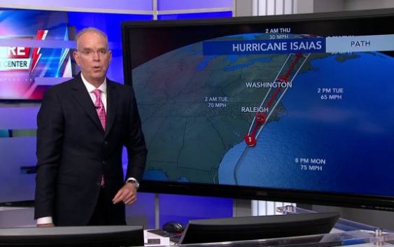
8 p.m. Isaias forecast update from WRAL Severe Weather Center
The WRAL Severe Weather team is tracking the tropics daily throughout hurricane season with the latest on storm tracks, expected impacts and safety at the coast.
well, David. Conditions are deteriorating at Down east of the coast, Carolina Beach, all the beaches in between. In fact, we have our first tornado warning for Eastern Brunswick County. Here’s a look in Carolina Beach You could see how rough the surf is. It’s raining hard. The water is on the lens of the camera getting and kind of like a milky look. But here’s a look at the velocities were now we use this tool all the time to look for rotation inside of thunderstorms. The radar site here is located just to the west of Wilmington, and what we’re looking at are a couple of little spins, little green area here just to the north and west of bald Head Island. There’s another one offshore, and so there’s a little span near your pond beach about 7 50 And now the tornado warning is in effect, I believe, until 8 15 and what we’re gonna see is these little spins making their way on land and is an encounter restriction. We may see tornado warnings issued, and that’s the 1st 1 of the evening, and these little spins little rotations will move to the north into the West getting closer to us now there’s where the hurricane is right now. It is moving to the north northeast at about 16 MPH, potentially making landfall near the North Carolina South Carolina line around midnight. So that means these bands that we’re seeing of heavier rainfall will be making their way farther north and west. So our weather conditions will gradually deteriorate as we go through the night. I believe this ban here will be across our southern counties by nine and 10 o’clock and then make their way farther north and west end of the triangle. And right now you see from Raleigh, North and West is the first band that came on by that have winds gusting 40 to 45. We have observation over an ocean isle that reported a wind gusting of 50 MPH as this band moved through the area. Now here’s the broader view. The storms about 70 miles south of Myrtle Beach, moving north northeast at 16 Hurricane s. I s as top winds right now of 75 MPH. We had mentioned that it briefly could become a hurricane prior to landfall. This is the storm track and intensities as we go through time. We do expect a new advisory at 11 tonight with a new forecast track. This is the track from five oclock this afternoon having the center of circulation moving over Sampson County in Duplin County, maintaining its intensity with winds a 70 MPH at that point. So that’s why we’re concerned that the storm will create wind damage as it moves through our 95 corridor. That means if you may lose power overnight tonight, we’ll have heavy rainfall, and it’s likely that this storm will quickly move on by and be in Southeast Virginia by 8 a.m. Tomorrow morning we have our tornado watch, in effect on a new tornado warning. It looks like it’s just popped up for parts of Brunswick and Columbus County. But right now, Sampson County is the only county in our viewing area that is under tornado watch. But we expect that the change as these bands move up to the North, the Tauron attic potential will increase, and we’ll probably see a new tornado watch issued prior to 2 a.m. And we’ll let you know about it as soon as it comes in by now, can’t Campbell is joining us. He’s got a look at the tropical storm warnings that are in effect on what kind of wins we’re going expect around here. Cat. The tropical storm force gusts are expected well inland from this storm. This is not just a coastal storm. That is why Wait County, as well as Cumberland County, points to the east or included in the tropical storm warning closer to the I 95 corridor. That’s where we could see gusts up to 70 MPH. Flash flooding and some of the coastal areas do have the potential for some minor storm surge. The more major storm surge is going to be closer to the North Carolina South Carolina border. That is where they could also see some winds gusting up to 70 MPH, potentially up to 80. Now that it’s at that hurricane status and a lot of rain is on the way. The flood watch is for the entire viewing area 3 to 5 inches of rain possible, with some locally higher totals. Possible flash flooding is our biggest concern. Some river flooding is possible as well, but if we take a look at the future cast rainfall town by town. We’re likely to see an access of very heavy rain set up for the areas in red. Here we could potentially see 4 to 6 inches of rain closer to the I 95 corridor in spots.