- Couple accused of creating videos of young girls using hidden cameras at The Woodlands Mall, Hurricane Harbor
- Couple accused of creating videos with hidden cameras at The Woodlands Mall, Hurricane Harbor
- The Texanist: Texas Gets More Tornadoes Than Any Other State, but Don’t Freak Out
- U.S. Supreme Court says Texans can sue state for flood damage
- This is how many hurricanes NC State researchers predict this year
Isaias upgraded to hurricane again, nearing landfall to Carolinas
Tropical Storm Watches and Warnings are up for eastern North and South Carolina as Hurricane Isaias moves north toward the Carolinas.
Isaías has strengthened and is once again a hurricane. It has sustained winds at 75 mph and wind gusts at 85 mph, as of the 8 p.m. advisory Monday. The storm is starting to get slightly more organized and starting to shift east a tad. This might mean a slightly farther east landfall in Eastern North Carolina.
Isaias has been struggling to remain organized as wind shear has been breaking up the storm and dry air as well. Stronger Tropical Storm force winds will affect Cape Canaveral, Florida this evening before picking up the pace towards South Carolina. Landfall is expected Monday night between Charleston to closer to Myrtle Beach. This area including Wilmington will likely experience the strongest winds early morning Tuesday. Areas like Raleigh will still have winds gusts from 35 to 55 causing downed trees.
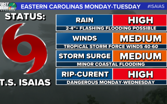
Regardless, Isaias will be weaker by the time it gets to the Carolinas and will be picking up speed. Forward wind speed will likely double keeping Tropical Storm conditions less than 6 hours for any given area in the eastern Carolina’s.
Our best news here is the speed at which this storm will move through the Carolinas. This limits all of the above expect for dangerous rip currents which are active even for this weekend.
RELATED: ‘Now is the time to prepare,’ Gov. Cooper declares a state of emergency ahead of Hurricane Isaias
YOUR LOCAL IMPACTS:
For the Charlotte area back to Hickory and Boone we might not even know it’s out there. We will see some clouds and breezy conditions, at times. The bigger impacts for rain will come from a slow-moving upper low and trough that will be hanging over the region through most of next week. Still, heavy rain and storms are possible through your late Monday and Tuesday morning associated with the outer bands working with that low mentioned above to promote scattered to widespread rain.
Stay tuned for later updates and follow up on Social Media for more updates on the storm as it gets closer to the Carolinas. Track forecast updates are coming out every day at 5AM, 11AM, 5PM, and 11PM until the storm is gone.