- Couple accused of creating videos of young girls using hidden cameras at The Woodlands Mall, Hurricane Harbor
- Couple accused of creating videos with hidden cameras at The Woodlands Mall, Hurricane Harbor
- The Texanist: Texas Gets More Tornadoes Than Any Other State, but Don’t Freak Out
- U.S. Supreme Court says Texans can sue state for flood damage
- This is how many hurricanes NC State researchers predict this year
Forecast: Most of central North Carolina under marginal risk for severe weather; gusty winds possible
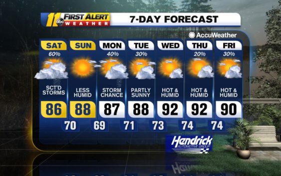
RALEIGH, N.C. (WTVD) — Tropical Rainstorm Laura will pass through the mid-Atlantic today as it migrates to the east out of the Tennessee Valley.
The majority of heavy rain will remain to the north over Virginia and Maryland, but a cold front building off Laura will sweep to the south into the Triangle, producing thunderstorms throughout the area. Some of these storms that pass through the region will be capable of producing damaging wind gusts and even an isolated tornado with help from increased shear and circulation from Laura.
The threat for stronger storms will be greatest in northeastern North Carolina, since the front will build in strength as it migrates eastward throughout the afternoon.
Otherwise, the day will be rather cloudy and cooler, with less humid conditions setting in towards the evening as a west-northwesterly flow sets up behind the passing cold front.
An area of high pressure is expected to briefly set up over the mid-Atlantic Sunday, ushering in a largely dry and sunny day with seasonable high temperatures. An upper-level trough moving into the region from the west could bring a shower or thunderstorm to the Piedmont and western areas of the Triangle as early as Sunday night, but another period of thunderstorms is expected to start early this week as this system passes through.
Warmer, more humid air will slowly return to the Triangle by midweek as a warm front from this system sets up a south-southwesterly flow, advecting moisture back into the region. Despite this, conditions for the second half of the week appear to be largely dry throughout the area as this front moves off to the north and stalls over the mid-Atlantic.
Have a great weekend,
Steve Stewart
Copyright © 2020 WTVD-TV. All Rights Reserved.