- U.S. Supreme Court says Texans can sue state for flood damage
- This is how many hurricanes NC State researchers predict this year
- NC State researchers predict above-average hurricane season
- Supreme Court rules in favor of property owners suing Texas over flood damage
- Texas Land Commissioner announces extension for Houston to distribute federal relief funds for Hurricane Harvey
Texas Gulf Coast On Alert As Tropical Storm Beta Grows In Power And Size
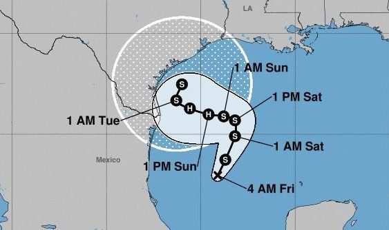
Tropical Depression 22 grew into Tropical Storm Beta on Friday, stepping into the center stage spotlight during a deadly hurricane season so active that it has become a meteorological drama not seen for 15 years. The National Hurricane Center forecasters warned Beta could soon strengthen into a hurricane by Sunday.
“Beta is moving toward the north-northeast near 9 mph, and this general motion is expected through Saturday,” the NHC advisory explained. “A slow westward motion is forecast to begin late Saturday or Saturday night, and this motion will likely continue into early next week. On the forecast track, the center of Beta will approach western coast of the Gulf of Mexico Sunday night and Monday.”
“Additional slow strengthening is expected through the weekend, and Beta could be near hurricane strength Sunday or Sunday night,” forecasters warned.
This storm was named Beta because Wilfred, the last name on the NHC’s 2020 list of “Tropical Cyclone Names,” went to a system in the eastern Atlantic that achieved tropical storm strength earlier on Friday, and the name Alpha, the first Greek name, went to a subtropical storm near the coast of Portugal.
Forecasters have not seen this level of activity since 2005. From now until Nov. 30, any systems that emerge over the Atlantic, Gulf or Caribbean waters and achieve tropical storm or hurricane strength will receive names from the Greek alphabet.
Weather expert Philip Klotzbach tweeted on Friday that the “2020 Atlantic #hurricane season has now generated 23 named storms – the same as the entire North Pacific through September 18. On average through 9/18, the Atlantic has had 8 named storms and the North Pacific has had 30 named storms.”
The National Weather Service in Corpus Christi pointed out in a tweet that “a Tropical Cyclone from the Greek alphabet has never made landfall in the Continental United States or its territories? The closest was Sub-Tropical Storm Alpha, which made landfall as a tropical depression across the Florida Panhandle in May of 1972!”
That could change by midweek.
Tropical Update:
Tropical Storm #Beta has developed in the Gulf and will slowly strengthen to hurricane strength over the next couple of days. Expect heavy rainfall and significant coastal flooding as #Beta approaches our coast.
Now is the time to finalize your preparations! pic.twitter.com/eK5ne0A135
— NWS Corpus Christi (@NWSCorpus) September 18, 2020
It was not entirely clear how severely the system would impact Texas, aside from the expected higher surf, storm surge and heavy rains that would likely soak coastal communities and cities hundreds of miles from the Gulf Coast for most of next week.
The latest track on Friday afternoon estimated Beta would skirt along the Texas coastline at least as far as Houston. The NHC’s rough estimate of that track did not attempt to predict where Beta would eventually make landfall, even though that forecast extended as far as Wednesday.
On Friday morning, Cameron County tweeted that residents “may experience tropical storm conditions including significant rainfall over the weekend and into early next week.” County emergency managers announced residents could pick up sandbags on Saturday morning.
We’re in the heart of #HurricaneSeason. Use this animation to communicate the dangers of #StormSurge to your community. https://t.co/GyMyMruRxl pic.twitter.com/HyIOt8ov3v
— NOAA Digital Coast (@NOAADigCoast) September 17, 2020
The depression in the Gulf of Mexico emerged near the end of a historically busy week in the Atlantic, Caribbean and Gulf regions.
Sally made a dangerously slow landfall near Gulf Shores, Ala., on Wednesday morning as a Category 2 hurricane, flooded several states throughout the southeastern U.S. and killed at least one person in Alabama.
By Thursday afternoon, the NHC had issued its final advisory on Sally — essentially closing the books on the drama — and officially classified it as a post-tropical depression. Sally’s remnants were expected to continue flooding Georgia and the Carolinas before moving out over the Atlantic.
The NHC also monitored Teddy, which grew to a Category 4 hurricane on Thursday and threatened Bermuda.
The 2020 Atlantic #hurricane season has already generated 81 ACE (Accumulated Cyclone Energy). That’s more than 29 full Atlantic hurricane seasons since 1950. ACE is integrated metric accounting for intensity and duration of tropical cyclones.https://t.co/GS9ik1a2cN pic.twitter.com/QAILyGfXev
— Philip Klotzbach (@philklotzbach) September 18, 2020
TPR was founded by and is supported by our community. If you value our commitment to the highest standards of responsible journalism and are able to do so, please consider making your gift of support today.