- The Texanist: Texas Gets More Tornadoes Than Any Other State, but Don’t Freak Out
- U.S. Supreme Court says Texans can sue state for flood damage
- This is how many hurricanes NC State researchers predict this year
- NC State researchers predict above-average hurricane season
- Supreme Court rules in favor of property owners suing Texas over flood damage
Tracking the Tropics: Tropical Depression 22 becomes Tropical Storm Beta
Tropical Depression 22 has strengthened into Tropical Storm Beta.
The Gulf system became Tropical Depression 22 Thursday evening and continues to strengthen, although its forecast track remains uncertain. It is now expected to possibly become a Category 1 hurricane over the next few days.
As of the 4 p.m. Friday update from the National Hurricane Center, Tropical Storm Beta had 40 mph sustained winds and was moving north-northeast at 9 mph. It’s 280 miles east-southeast of the mouth of the Rio Grande.
1. Tropical Depression Twenty-Two is expected to strengthen to a tropical storm, and possibly a hurricane, while moving slowly over the western Gulf of Mexico during the next few days.
2. There is an increasing risk of heavy rainfall and flooding along the Texas coast from Sunday through at least the middle of next week as the system is forecast to move slowly near the Texas coast. For additional information, see products from your local National Weather Service office.
3. While it is too early to determine what areas could see direct wind and storm surge impacts from this system, interests throughout the western Gulf of Mexico should monitor the progress of this system and future updates to the forecast.
In Houston, we can’t say for sure what this tropical disturbance means for our local forecast. You will see in the forecast images below the European spaghetti models bring heavy rainfall to the Southeast Texas coast early next week, but these models will continue to change. We’ll want to watch this closely through the weekend.
The Houston area and Southeast Texas are expected to get a “cool front” on Friday that should help steer away any tropical development. (About that cool front: it will still be warm this weekend, but Houston’s weather will feel much nicer thanks to lower humidity. View Houston’s forecast here.)
Tropical Depression 22 forecast cone
Tropical Depression 22 spaghetti models
Gulf Coast rainfall forecast (Euro model)
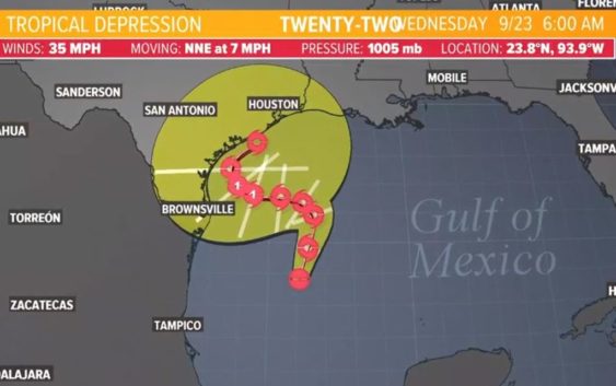
10 a.m. Friday update from the National Hurricane Center:
LOCATION…23.8N 93.9W
ABOUT 275 MI…445 KM ENE OF TAMPICO MEXICO
ABOUT 255 MI…405 KM SE OF MOUTH OF THE RIO GRANDE
MAXIMUM SUSTAINED WINDS…35 MPH…55 KM/H
PRESENT MOVEMENT…NNE OR 15 DEGREES AT 7 MPH…11 KM/H
MINIMUM CENTRAL PRESSURE…1005 MB…29.68 INCHES
Interests along the western Gulf of Mexico coast should monitor the progress of the depression.
DISCUSSION AND OUTLOOK
———————-
At 1000 AM CDT (1500 UTC), the center of Tropical Depression Twenty-Two was located near latitude 23.8 North, longitude 93.9 West. The depression is moving toward the north-northeast near 7 mph (11 km/h), and this general motion is expected through early Saturday. A slow westward motion is forecast to begin late Saturday or Saturday night, and this motion will likely continue into early next week. Maximum sustained winds are near 35 mph (55 km/h) with higher gusts. Strengthening is forecast during the next few days, and the
depression is expected to become a tropical storm later today. The system could be near or at hurricane strength by Sunday. The estimated minimum central pressure is 1005 mb (29.68 inches).
HAZARDS AFFECTING LAND
———————-
SURF: Swells are expected to increase and reach the coast of Texas and the Gulf Coast of Mexico over the weekend, generated by a
combination of the depression and a cold front entering the northern Gulf of Mexico. These swells are likely to cause
life-threatening surf and rip current conditions.
Be prepared if tropical weather does come our way
BEFORE THE STORM
- Make a home inventory
- Have a current copy of your declarations page that has your policy number and your agent’s number
- Review your policy with your insurance agent to determine if you have adequate coverage
- Repair loose boards, shingles, shutters and downspouts to prevent them from becoming an issue in high winds or torrential rain
- Have an evacuation plan, and include plans for your pets
- Make sure your emergency equipment is in working order, including a battery-powered radio, flashlights and extra batteries. Also, make sure to gather all medicine, replenish your first-aid kit and stock a week’s worth of non-perishable food and water
- Charge your cell phone and fill your car with gas
- Program all emergency phone numbers
DURING THE STORM
- If you are advised to evacuate, leave as soon as possible. Retain all related receipts – they may be considered in your claim. If you aren’t in a recommended evacuation and you plant to stay home, stay informed by listening to weather alerts
- Keep windows and doors closed at all time, and, if possible, board them up with wooden or metal shutters
- Stay away from the windows and in the center of the room, or, stay in an interior room
- Avoid flood water, as it may be electrically charged from downed power lines
- Check on family members and friends
AFTER THE STORM
- Check to be sure your family members are safe
- If you did evacuate, wait for official notice that it is safe to re-enter your neighborhood and your house
- Document damaged property, and take photos and videos. Don’t dispose of any damaged items without approval
- Keep a record of any temporary repairs or expenses to prevent further damage to your property