- Couple accused of creating videos of young girls using hidden cameras at The Woodlands Mall, Hurricane Harbor
- Couple accused of creating videos with hidden cameras at The Woodlands Mall, Hurricane Harbor
- The Texanist: Texas Gets More Tornadoes Than Any Other State, but Don’t Freak Out
- U.S. Supreme Court says Texans can sue state for flood damage
- This is how many hurricanes NC State researchers predict this year
Tropical Storm Warnings issued for southeast Texas as Beta makes landfall near Matagorda peninsula
Flash Flood Warning for Brazoria, Fort Bend, Galveston and Harris counties until 11:30 p.m. Monday.
HOUSTON — Tropical Storm Beta made landfall Monday night around 10 p.m. near the southern end of the Matagorda Bay peninsula with sustained winds of 45 mph.
Rain totals have been heaviest near the coast. Minor street flooding is occurring along low lying and coastal roads near the coast and the west side of Galveston Bay.
WEATHER ALERTS:
- Flash Flood Warning for Brazoria, Fort Bend, Galveston and Harris counties until 11:30 p.m. Monday.
- Weather Flash Flood Warning issued for Brazoria, Matagorda, and Wharton County until 1 a.m.
Rain will continue to sweep in across the Houston Galveston area overnight and through the day on Tuesday. A Flash Food Watch is in effect for the entire area.
Beta is now moving at 3 mph, down from 7 mph, according to the 10 p.m. update from the National Hurricane Center. Max sustained winds have slowed to 45 mph.
The storm is expected to make landfall on Monday evening near Port Lavaca, which is about 100 miles southwest of Houston. There was little change in its projected path overnight. Once inland, the storm will move northeast along the coast through Wednesday, becoming a depression by the time it reaches Houston.
Watch Meteorologist Addison Green’s latest forecast
What can Houston and Southeast Texas expect?
Periods of fast moving, heavy rain are expected to continue late Monday evening into the day on Tuesday. Coastal flooding in low-lying areas is the greatest threat with this system so far.
At this time we are not expecting widespread flooding issues across our inland communities. Because of this, the City of Houston has not set up any emergency shelters.
You will see in the images below that all of the Greater Houston Area is under a Flash Flood Watch, and our coastal communities are under a Storm Surge Warning.
The latest: Updates on TS Beta from across the Houston area
“As Beta continues to get closer to the coastline and turn north, some of the rain bands in the Houston area will get a little more intense,” said KHOU 11 Meteorologist Chita Craft.
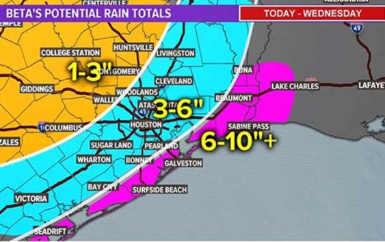
Our primary concern with this system will be isolated spots of street flooding during those heavy downpours and flooding/storm surge in our coastal communities. Areas inland could receive up to 7 inches of rain as Beta moves up the coast over the next 24 to 48 hours.
Interactive tropical tracker map
Tropical Storm Beta forecast track / cone
Tropical Storm Beta potential rainfall totals
Tropical Storm Warning in Southeast Texas
**Text STORM to 713-526-1111 for updates on Tropical Storm Beta**
10 p.m. Monday update from the National Hurricane Center:
CENTER OF BETA NEARING THE TEXAS COAST… …HEAVY RAINS OCCURRING OVER THE CENTRAL TEXAS COASTAL AREA…
LOCATION…28.4N 96.3W
ABOUT 5 MI…10 KM E OF PORT OCONNOR TEXAS
ABOUT 25 MI…35 KM SW OF MATAGORDA TEXAS
MAXIMUM SUSTAINED WINDS…45 MPH…75 KM/H
PRESENT MOVEMENT…NW OR 325 DEGREES AT 3 MPH…6 KM/H
MINIMUM CENTRAL PRESSURE…999 MB…29.50 INCHES
WATCHES AND WARNINGS | CHANGES WITH THIS ADVISORY:
SUMMARY OF WATCHES AND WARNINGS IN EFFECT:
A Storm Surge Warning is in effect for… * Port Aransas, Texas to Sabine Pass, Texas including Copano Bay, Aransas Bay, San Antonio Bay, Matagorda Bay, and Galveston Bay.
A Tropical Storm Warning is in effect for… * Port Aransas Texas to Morgan City Louisiana
A Storm Surge Warning means there is a danger of life-threatening inundation, from rising water moving inland from the coastline, during the next 36 hours in the indicated locations. For a depiction of areas at risk, please see the National Weather Service Storm Surge Watch/Warning Graphic, available at hurricanes.gov. This is a life-threatening situation. Persons located within these areas should take all necessary actions to protect life and property from rising water and the potential for other dangerous conditions. Promptly follow evacuation and other instructions from local officials.
A Tropical Storm Warning means that tropical storm conditions are expected somewhere within the warning area.
For storm information specific to your area, including possible inland watches and warnings, please monitor products issued by your local National Weather Service forecast office.
DISCUSSION AND OUTLOOK
———————-
At 1000 PM CDT (0300 UTC), the center of Tropical Storm Beta was located near latitude 28.4 North, longitude 96.3 West. Beta is moving toward the northwest near 3 mph (6 km/h), and this general motion is forecast to continue tonight. A slow north and northeast motion are expected on Tuesday, and a faster east-northeastward motion should begin Tuesday night and continue Wednesday. On the forecast track, the center of Beta will move inland overnight. Beta is forecast to remain near or just offshore the coast of southeastern Texas on Tuesday and Wednesday.
Data from an Air Force Reserve reconnaissance aircraft indicate that the maximum sustained winds are near 45 mph (75 km/h) with higher gusts. Little change in strength is forecast before Beta reaches the Texas coast. Weakening is anticipated on Tuesday as Beta moves just inland along the Texas coast.
Tropical-storm-force winds extend outward up to 125 miles (205 km) from the center. A WeatherFlow observing site at Matagorda Bay, Texas, has reported sustained winds of 41 mph (67 km/h) with a gust to 53 mph (85 km/h) this evening.
The estimated minimum central pressure is 999 mb (29.50 inches).
HAZARDS AFFECTING LAND
———————-
Key messages for Beta can be found in the Tropical Cyclone Discussion under AWIPS header MIATCDAT2 and WMO header WTNT42 KNHC.
STORM SURGE: The combination of a dangerous storm surge and the tide will cause normally dry areas near the coast to be flooded by rising waters moving inland from the shoreline. The water could reach the following heights above ground somewhere in the indicated areas if the peak surge occurs at the time of high tide Port Aransas, TX to Sabine Pass, TX including Copano Bay, Aransas Bay, San Antonio Bay, Matagorda Bay, and Galveston Bay…2-4 ft Sabine Pass, TX to Ocean Springs, MS including Sabine Lake, Lake Calcasieu, Vermilion Bay, Lake Borgne, Lake Pontchartrain, and Lake Maurepas…1-3 ft Baffin Bay, TX to Port Aransas, TX including Corpus Christi Bay and Baffin Bay… 1-3 ft Mouth of the Rio Grande to Baffin Bay, TX…1-2 ft
The deepest water will occur along the immediate coast in areas of onshore winds, where the surge will be accompanied by large and dangerous waves. Surge-related flooding depends on the relative timing of the surge and the tidal cycle, and can vary greatly over short distances. For information specific to your area, please see products issued by your local National Weather Service forecast office.
WIND: Tropical storm conditions are expected to continue within portions of the tropical storm warning area through Tuesday.
RAINFALL: Through Friday, Beta is expected to produce rainfall accumulations of 5 to 10 inches with isolated totals of 15 inches from the middle Texas coast to southeast Louisiana. Rainfall totals of 3 to 5 inches are expected northward into the ArkLaTex region and east into the Lower Mississippi Valley through the end of the week. Flash and urban flooding is likely, as well as isolated minor river flooding.
TORNADOES: A tornado or two could occur through Tuesday near the middle to upper Texas coast or the southwestern Louisiana coast.
SURF: Swells generated by a combination of Beta and a cold front over the northern Gulf of Mexico will continue along the coasts of Louisiana and Texas during the next couple of days. These swells are likely to cause life-threatening surf and rip current conditions. Please consult products from your local weather office.