- Couple accused of creating videos of young girls using hidden cameras at The Woodlands Mall, Hurricane Harbor
- Couple accused of creating videos with hidden cameras at The Woodlands Mall, Hurricane Harbor
- The Texanist: Texas Gets More Tornadoes Than Any Other State, but Don’t Freak Out
- U.S. Supreme Court says Texans can sue state for flood damage
- This is how many hurricanes NC State researchers predict this year
Tropical Depression 25 strengthens into Tropical Storm Gamma in western Caribbean
There are no immediate tropical threats to the Texas coast or American mainland at this time.
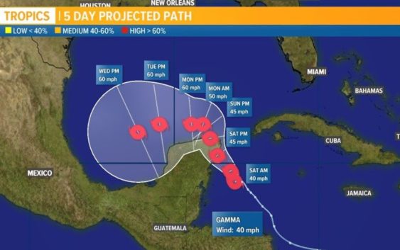
HOUSTON — Tropical Depression 25 has strengthened into Tropical Storm Gamma in the northwest Caribbean Sea Friday evening.
The storm is about 135 miles southeast of Cozumel, Mexico with maximum sustained winds of 40 mph. It is moving northwest at 9 mph.
It is now expected to go northwest over the northern edge of the Yucatan Peninsula and enter the southern Gulf of Mexico by early Tuesday morning of next week.
What happens after that is still unknown, but there is some good news for Texas and the U.S. as Meteorologist Chita Craft says another frontal boundary will push south, helping to keep Gamma away from the U.S. mainland.
Interactive tropical tracker:
Either way we will want to watch it closely through the weekend as the spaghetti models are not yet all in agreement about its path in the Gulf. Some have it going to the west once in the Gulf, but earlier forecasts had it going east toward Florida.
As you can see above, there are two tropical disturbances we are tracking right now. The other one, to the east, now has a 0% chance over two days and 30% chance of further development over five days as it moves into the Caribbean.
Get updates on both below from the NHC.
Friday evening update from the National Hurricane Center:
At 7 p.m. CDT, the center of Tropical Storm Gamma was located near latitude 18.8 North, longitude 85.8 West. Gamma is moving toward the northwest near 9 mph (15 km/h), and a gradual turn toward the north-northwest with a decrease in forward speed is expected over the next couple of days. On the forecast track, the center of the tropical cyclone should be near the northeastern Yucatan Peninsula on Saturday.
Maximum sustained winds are near 40 mph (65 km/h) with higher gusts. Slow strengthening is forecast during the next few days.
The estimated minimum central pressure based on data from the Air Force Hurricane Hunters is 1000 mb (29.53 inches). the Gulf Coast or Texas
The good news is elsewhere the tropics remain very quiet with no development expected in the Atlantic over the next three days, says Craft. This means there is also no threats to Texas or the rest of the American mainland.
RAINFALL: Gamma is expected to produce rainfall of 4 to 8 inches with isolated maximum amounts of 12 inches in portions of the Yucatan Peninsula and far western Cuba. A separate area of significant rain is expected to develop well away from the center in the Mexican states of Campeche, Tabasco, and northern Chiapas with rainfall of 8 to 12 inches and isolated maximum amounts of 20 inches. This rainfall may produce life-threatening flash floods and mudslides.
Rainfall of 1 to 3 inches with maximum amounts of 5 inches is expected in the Bay Islands of Honduras and over the Cayman Islands.
WIND: Tropical storm conditions are expected within the Tropical Storm Warning area by Saturday morning, and are possible within the Tropical Storm Watch area on Saturday and Sunday.
The 2020 hurricane season is so active, we ran out of names
The Atlantic hurricane season doesn’t officially end until Nov. 30, and we’ve already run out of letters for named storms. X, Y and Z aren’t used so Tropical Storm Wilfred was the last one. For only the second time in history, the National Hurricane Center has switched to the Greek alphabet for storm names. Read more and see the list of upcoming names here.