- The Texanist: Texas Gets More Tornadoes Than Any Other State, but Don’t Freak Out
- U.S. Supreme Court says Texans can sue state for flood damage
- This is how many hurricanes NC State researchers predict this year
- NC State researchers predict above-average hurricane season
- Supreme Court rules in favor of property owners suing Texas over flood damage
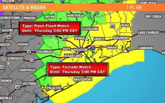
Houston weather: Flash Flood Watch, Tornado Watch as cold front sweeps through | View live radar
And the temperatures are about to plunge into the 30s and 40s as we ring in 2021.
HOUSTON — The overnight hours were relatively calm weather-wise in Houston proper, but we can’t let our guard down yet.
A Tornado Watch remains in effect for Chambers, Galveston and Liberty counties until 3 p.m.
There is also a Flash Flood Watch for parts of the Houston area through 3 p.m. today.
Much of the heavy rainfall overnight kept west of Houston, but it is expected to get into our area later this morning into the early afternoon. Expect on and off rain with the potential of isolated thunderstorms that will be capable of producing another 1-3 inches of rain. Keep your guard up for high water spots. They will be a concern through our early afternoon because the ground is already saturated from yesterday’s rainfall.
The Pearland area has seen some heavy rains, leaving some roads impassible.
Our cold front is splitting the temperatures throughout the area in half this morning, but soon it will be cold across town.
Starting tomorrow, New Year’s Day, we will be under clear skies but cold temperatures. Temperatures will drop in to the 30s overnight.
What does a Tornado Watch mean?
From the National Weather Service: “A watch means that conditions are favorable for severe weather and possible tornadoes, so be prepared to take action! If a warning is issued, then that means there is an imminent threat, so take action!”